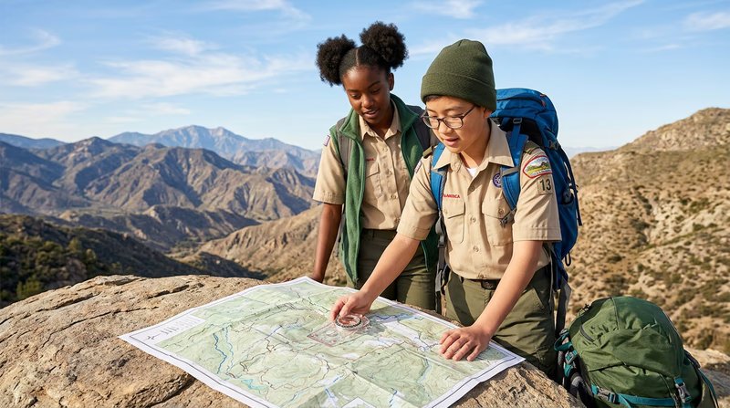
Req 6 — Navigation
This requirement covers three navigation skills every backpacker must master:
- Reading topographic maps — understanding the landscape before you see it
- Using a map and compass or GPS — establishing your position on the ground
- Staying found — and what to do if you get lost
6a. Reading Topographic Maps
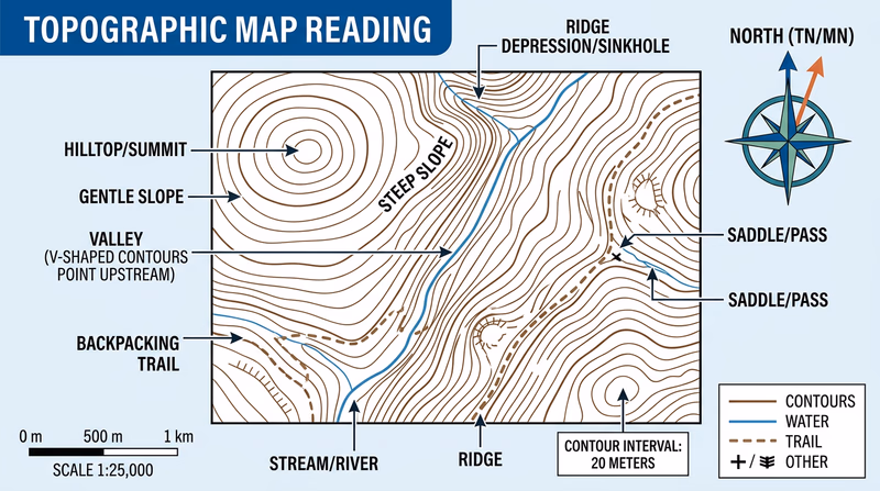
A topographic map (or “topo map”) uses contour lines to show the three-dimensional shape of the land on a flat piece of paper. Unlike a road map that just shows streets, a topo map reveals ridges, valleys, cliffs, lakes, and streams — everything you need to plan a route through the backcountry.
Key Features of a Topo Map
- Contour lines: Brown lines that connect points of equal elevation. Every point along a single contour line is at the same height above sea level.
- Contour interval: The elevation difference between adjacent contour lines, printed in the map legend (commonly 40 feet on USGS maps). Closer lines mean steeper terrain; widely spaced lines mean gentle slopes.
- Index contours: Every fifth contour line is drawn thicker and labeled with its elevation. These help you quickly read elevation.
- Scale: Tells you the ratio between map distance and real-world distance. A 1:24,000 scale (the standard USGS “7.5-minute” map) means 1 inch on the map equals 24,000 inches (2,000 feet) on the ground.
- Legend/key: Explains all symbols — trails, roads, buildings, water features, vegetation, and more.
- Declination diagram: Shows the difference between magnetic north (where your compass points) and true north (where the map grid points). You must adjust for this difference when navigating.
Reading the Terrain
With practice, you can “see” the landscape by looking at contour lines:
- Close together = steep slope (cliff if they merge)
- Far apart = gentle slope or flat ground
- V-shapes pointing uphill = valley or stream drainage
- V-shapes pointing downhill = ridge or spur
- Closed circles = hilltop or summit
- Concentric closed circles with tick marks = depression
6b. Establishing Your Position
Knowing where you are on the map at any given moment is the core skill of backcountry navigation. Here are two methods:
Method 1: Map and Compass (Triangulation)
- Orient your map: Place the compass on the map and rotate the map until the compass needle aligns with the map’s north arrow (adjusting for declination).
- Identify two or three landmarks you can see — a prominent peak, a lake, a trail junction.
- Take a bearing to each landmark with your compass.
- Draw lines (or imagine them) on the map from each landmark along the reverse bearing.
- Where the lines intersect is your approximate position.
Method 2: GPS Receiver
- Turn on your GPS device and wait for it to acquire satellite signals.
- Read your coordinates (latitude/longitude or UTM grid reference).
- Plot those coordinates on your topo map using the grid lines printed on the map.
6c. Staying Found
The best navigation strategy is to never get lost in the first place. Experienced backpackers call this “staying found” — constantly keeping track of where you are so you never reach a point of confusion.
How to Stay Found
- Check your map frequently. Every 15–20 minutes, compare what you see around you to what the map shows. Look for landmarks — ridgelines, stream crossings, trail junctions.
- Track your pace. Know roughly how fast you travel (a common hiking pace is 2 miles per hour on flat terrain, slower uphill). Use your watch and speed to estimate how far you have gone.
- Note landmarks as you pass them. Make a mental (or written) note of distinctive features: “Crossed a wooden bridge at 10:15 AM” or “Passed the Y-junction where the trail splits left toward the lake.”
- Look back. Periodically turn around and observe the trail from the opposite direction. If you need to retrace your steps, the trail looks completely different going the other way.
- Keep your crew together. Everyone should be within sight or shouting distance of the person ahead and behind them.
What to Do If You Get Lost
If you realize you do not know where you are, use the STOP method: