Req 9 — Plan and Run a Geohunt
This requirement asks you to stop being just a participant and become the organizer. A good geohunt is part navigation challenge, part lesson, and part game. If it is well planned, the players have fun and learn real GPS skills at the same time.
Start with a theme
A theme gives the geohunt personality. It might be nature, local history, Scout skills, conservation, camp landmarks, or a simple adventure story. The theme helps you decide what the waypoints represent and how players move through the course.
For example, a conservation geohunt might send players to stations about water, wildlife, litter prevention, and trees. A camp history geohunt might use waypoints that teach the story of different landmarks.
Design the course
Your course needs at least four waypoints, but the best courses are not just four random dots on a screen. The waypoints should make sense as a sequence. They should also be safe, easy to supervise, and suitable for the age of the players.
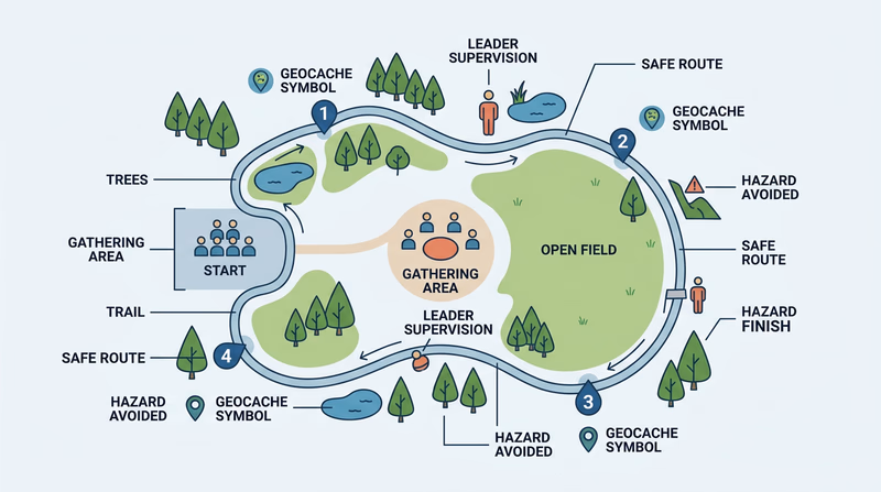
When designing the course, think about:
- how far players will walk
- whether the route crosses roads or other hazards
- where leaders can supervise the group
- whether the terrain matches the age and skill of the participants
- what each waypoint teaches or reveals
Strong Geohunt Design
What to build before the event
- Clear theme: Give the hunt a story or purpose.
- At least four waypoints: Make each one count.
- Safe route: Avoid hazards, confusion, and poor supervision areas.
- Simple player materials: Maps, clue sheets, waypoint lists, or scorecards.
Teach GPS before the game starts
This requirement specifically says you must teach the players how to use a GPS unit. That means the geohunt should begin with instruction, not confusion. Show the players how to read direction and distance, how to move toward a waypoint, and what to do when they get close.
Keep the lesson short and practical. A long lecture will drain the energy out of the game. A quick demonstration followed by hands-on practice is usually best.
You can use the same EDGE ideas from Req 4: explain, demonstrate, guide, and then let them try.
Run the event and watch what happens
Once the players start, your job shifts from planner to leader. Observe whether the waypoints are clear enough, whether the groups understand the devices, and whether the pace matches the age level.
Do not be surprised if something needs adjusting. Real events almost always teach you what the paper plan missed.
Materials to save for your counselor
The requirement asks you to share the materials you used and developed. That might include:
- waypoint list
- map of the course
- clue sheet or scorecard
- safety plan
- teaching notes
- event schedule
The more organized your materials are, the easier it will be to explain the event afterward.
Telling your counselor about the experience
After the event, reflect on what worked and what did not. Your counselor will likely care about both. A strong reflection includes:
- what your theme was and why you chose it
- how the course was laid out
- how you taught GPS skills
- how the players responded
- what you would improve if you ran it again
That reflection shows leadership. Good leaders do not just complete an event. They learn from it.
Geocaching started with a simple find, but this requirement shows how far the badge can go. You are now planning, teaching, leading, and evaluating — all with navigation as the core skill.