Req 3 — Geologic Maps
A geologic map can look confusing at first — bright colors, symbols, lines, and abbreviations spread across a landscape. But each color patch stands for real rock at the surface, and the symbols tell you how those rocks are tilted, broken, or related in age. Once you know how to read the legend and look for patterns, a geologic map becomes one of the most powerful tools in geology.
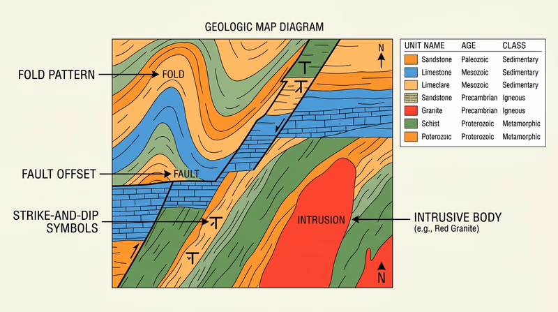
Start With the Legend
The legend is your translator. It explains what each color or pattern means and usually lists the rock unit name, its age, and often its rock type. Before you try to interpret anything else, find:
- The rock unit names
- The age labels
- Any notes about whether the rocks are sedimentary, igneous, or metamorphic
- Symbols showing faults, contacts, or strike and dip
Rock Classes on a Map
When you examine the units, sort them into the three major rock classes:
- Sedimentary rocks form from deposited material such as sand, mud, shells, or chemical precipitates. On maps these may appear as sandstone, shale, limestone, conglomerate, or similar units.
- Igneous rocks form from cooled magma or lava. These might appear as basalt, granite, rhyolite, diorite, and more.
- Metamorphic rocks started as older rocks but were changed by heat, pressure, or fluids. Schist, gneiss, quartzite, slate, and marble are common examples.
How to Estimate the Ages
Most maps place rock units in geologic order. Younger units may lie on top of older ones unless faulting, folding, or intrusion changed the pattern. The legend may use era and period names such as Cretaceous, Jurassic, Pennsylvanian, or Precambrian. You do not need to memorize every date, but you should notice whether your local rocks are relatively young or very old and which units are older or younger than others.
Recognizing Structure
This is where the map becomes a puzzle.
Horizontal Rocks
Horizontal rocks often appear as broad bands or areas that match the landscape without much repetition. The map may show little or no tilt in the symbols. If a sequence is not bent or broken, the pattern is usually simpler.
Folded Rocks
Folded rocks often repeat in curved or parallel bands. If layers have been bent into anticlines and synclines, the same units may show up again and again across the map. Strike-and-dip symbols may point in different directions on opposite sides of a fold.
Faulted Rocks
Faults are breaks where rocks moved. On the map they often appear as lines cutting across units and offsetting them. A rock layer that should continue smoothly may suddenly jump to a new position.
Intrusive Rocks
Intrusions are bodies of magma that pushed into older rock underground. On a map they may cut across surrounding layers instead of following them. That cross-cutting relationship is a big clue that the intrusion is younger than the rock it enters.
How to Read a Geologic Map
A step-by-step approach for your counselor discussion
- Pick one map area. Do not try to interpret the whole state at once.
- Read the legend first. Match colors to rock names and ages.
- Sort the units. Decide which ones are sedimentary, igneous, or metamorphic.
- Look for patterns. Are units flat, repeated, offset, or cut by another body?
- Explain your evidence. Point to the map features that support your conclusion.
A Sample Explanation Style
A strong explanation sounds like this: “This unit is labeled limestone and dated to the Mississippian Period, so it is a sedimentary rock. The bands of rock repeat in a curved pattern, and the symbols show changing dip directions, so I think the rocks are folded. This igneous body cuts across the surrounding units, so it must be intrusive and younger than those rocks.”
That kind of answer is better than simply saying, “I think it is folded,” because it tells your counselor why you think so.
State geological surveys are often the best place to find maps, legends, and explanatory notes. Use the official resource below to locate the survey for your area or another approved area.
Official Resources
State Geological Surveys (website) Find state survey websites with geologic maps, legends, and background notes you can use for this requirement.You have now practiced one of the core skills geologists use in the field. Next comes the biggest choice in the badge: which geology branch you want to explore in depth.