Req 4a2 — Stream Gradients
A stream does not need to look wild to be powerful. The slope of the land underneath it matters a lot. A stream dropping quickly over a short distance usually has more energy than one crossing a broad, gentle floodplain. Gradient gives you a way to compare that energy.
What Gradient Means
Gradient is the change in elevation divided by the distance over which that change happens. In simple terms, it tells you how steep the stream is.
- A high gradient stream drops a lot over a short distance.
- A low gradient stream drops only a little over the same distance.
Higher gradient often means faster water, more erosion, and a better ability to move larger sediment.
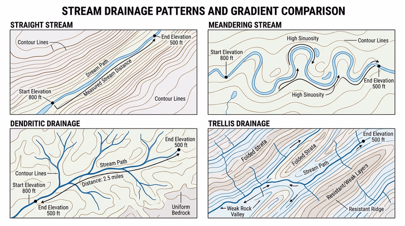
The Four Stream Patterns
Your maps may show four drainage styles named in the requirement:
- Straight — a relatively direct channel, often controlled by slope, structure, or confinement.
- Meandering — a winding channel with bends, common on flatter ground.
- Dendritic — a branching pattern that looks like tree limbs, common where rock types are fairly uniform.
- Trellis — a network with main streams and short side streams joining at near-right angles, often influenced by alternating hard and soft rock or folded terrain.
These names describe pattern, not just speed. That is why you need the map and gradient calculation together.
How to Calculate It
- Pick two points on the stream segment your counselor wants you to compare.
- Read the elevation at both points from contour lines or labeled elevations.
- Subtract the lower elevation from the higher elevation.
- Measure the distance between those points along the stream path.
- Divide elevation change by distance.
Gradient Workflow
Use the same method for all four stream types
- Mark the start and end points clearly.
- Write down both elevations.
- Calculate the elevation drop.
- Measure the channel distance, not straight-line distance.
- Keep your units consistent. Feet per mile or meters per kilometer both work.
Which Streams Carry Larger Sediment?
In general, streams with more energy can carry larger grains. Energy depends on several things, but gradient is a major factor. A steep stream is more likely to move gravel, pebbles, or even cobbles than a slow lowland stream. A meandering stream on a gentle floodplain is more likely to deposit sand, silt, and mud in many locations.
That does not mean every straight stream is faster than every meandering stream. The pattern type alone does not answer the question. Your actual map measurements do.
How to Explain Your Conclusion
Your counselor is looking for reasoning, not just numbers. A good answer sounds like this: “This stream had the highest calculated gradient, so the water should flow faster and have more power to move larger grains. The lower-gradient meandering stream would lose energy more easily and deposit finer sediment.”
The official video below walks through the idea of slope calculation so you can check your math method.
Official Resources
Next you will move from maps to a stream diagram and identify the features produced by flowing water as channels bend and deposit sediment.