Req 4b3 — Tools for Finding Oil and Gas
Geologists cannot usually see an oil or gas reservoir directly. Instead, they build an underground picture from many partial clues. Each tool in this requirement adds one piece of that hidden puzzle.
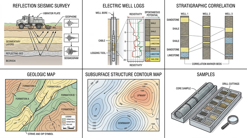
The Exploration Tools
Reflection Seismic
Reflection seismic sends energy waves into the ground and records how they bounce back from different rock layers. This helps geologists map buried structures such as folds, faults, and possible traps.
Electric Well Logs
Electric well logs measure properties inside a borehole, such as resistivity and natural radiation. These data help geologists identify rock types, fluids, porosity, and layer boundaries.
Stratigraphic Correlation
Stratigraphic correlation means matching rock layers from one location to another. Geologists compare rock type, fossils, well-log patterns, and position in the sequence to trace units across a region.
Offshore Platform
An offshore platform is not just a drilling structure. It is also a working place where geologists and engineers gather data, monitor drilling, and investigate offshore resources.
Geologic Map
A geologic map shows what is exposed at the surface. Even if the target resource is buried, surface patterns often reveal folds, faults, rock ages, and structures that continue underground.
Subsurface Structure Map
A subsurface structure map shows the shape or elevation of a buried layer. It helps geologists locate highs, lows, domes, and traps that may hold oil or gas.
Subsurface Isopach Map
An isopach map shows thickness variation of a rock unit. Thickness changes can reveal ancient channels, basins, depositional centers, and places where reservoir quality may differ.
Core Samples and Cutting Samples
Core samples are cylinders of rock brought up intact. Cutting samples are small rock fragments produced while drilling. Both let geologists examine the actual rock instead of only indirect data.
What Each Tool Answers
Think of exploration as a set of geology questions
- What structures are underground? Reflection seismic, structure maps
- What rock is present in the well? Well logs, cores, cuttings
- How do layers connect regionally? Stratigraphic correlation, geologic maps
- How thick is the unit? Isopach maps
- How do offshore geologists gather direct data? Platforms, drilling, samples
Official Resources
Your next page turns this idea into action by having you build and interpret a subsurface structure map from real data points.