Req 1 — Cultural Areas
A kayak built for Arctic waters, a buffalo-hide tipi on the Plains, and a multistory pueblo in the Southwest did not appear by accident. Each one reflects a different environment, different materials, and different ways communities met daily needs. That is the heart of cultural areas: they help you compare how Native nations adapted to different places without pretending every nation was identical.
A good way to handle this requirement is to learn the broad regions first, then attach memorable details to each one. Focus on climate, housing, food, transportation, arts, and community life. If you can explain how place shaped culture, you are doing the requirement well.
What to notice in each cultural area
Use the same lens for each region so your comparison stays organized
- Land and climate: Is it coastal, forested, dry, mountainous, grassy, or Arctic?
- Homes and materials: What did people build with what was available nearby?
- Foodways: What was farmed, hunted, fished, gathered, or traded?
- Transportation: How did people move across water, snow, desert, or open plains?
- Arts and identity: What designs, materials, and ceremonial traditions stand out?
Commonly Taught Cultural Areas
Different books divide the map a little differently, but these are the regions Scouts most often learn:
Arctic
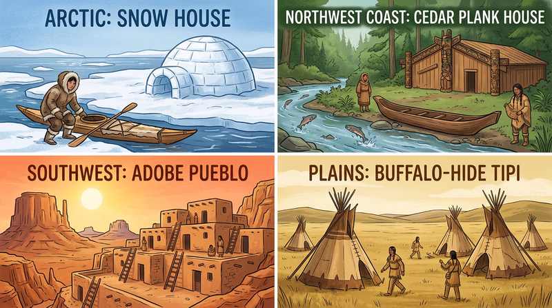
The Arctic includes far northern lands with long winters, sea ice, and short growing seasons. Communities relied heavily on marine mammals, fish, caribou, and careful seasonal travel. Clothing, shelter, and tools had to work in extreme cold, so skill with animal skin, bone, ivory, and snow was essential.
Subarctic
The Subarctic stretches across cold northern forests. Travel often depended on canoes in warmer months and snowshoes in winter. Many groups followed seasonal hunting, fishing, and gathering cycles through dense woodlands and lakes.
Northwest Coast
This rainy coastal region is known for cedar forests, salmon-rich rivers, and ocean travel. Large plank houses, carved poles, canoes, and rich artistic traditions all reflect abundant wood and access to the sea. Wealth and ceremony often played major roles in community life here.
Plateau
The Plateau lies inland between mountain ranges in the Northwest. River fishing, especially for salmon, was extremely important, along with seasonal gathering and trade. People adapted to a landscape of river valleys, dry uplands, and mountain corridors.
Great Basin
The Great Basin is a dry region of deserts, mountains, and inland valleys. Water sources shaped movement and settlement. Communities often lived in smaller groups and relied on deep knowledge of seeds, roots, small game, and seasonal resources.
California
California Native cultures developed in a region with major ecological variety: coastlines, oak woodlands, valleys, and mountains. Acorns were a major food in many communities, and basketry became one of the most refined art forms anywhere in North America.
Southwest
The Southwest includes deserts, mesas, and river valleys. Farming, irrigation, adobe or stone pueblos, and strong community planning are major themes. In some places, weaving, pottery, and multistory dwellings reflect long-settled agricultural life in a dry environment.
Plains
The Plains are known for grasslands, large bison herds, and long-distance travel. After horses spread through the region, mobility changed dramatically for many nations. Tipis, buffalo-hide technologies, and strong riding traditions are often associated with the Plains, though the region includes many different nations with different histories.
Northeast
The Northeast includes forests, lakes, and river systems. Wigwams and longhouses, farming, fishing, and woodland hunting all shaped life there. Confederacies and alliances are an important part of the region’s history, especially in discussions of diplomacy and governance.
Southeast
The Southeast has warm climates, rich river valleys, and a long farming tradition. Town life, ceremonial centers, mound building in earlier periods, and complex political systems are key themes. River travel and agriculture were especially important.
How to Explain What Makes a Region Unique
Do more than name the region. Build a short comparison sentence. For example: “The Northwest Coast was unique because cedar forests and ocean resources supported large plank houses, canoe travel, and major salmon fishing traditions.” That structure works for every area.
You can also compare regions directly:
- The Arctic and Southwest both required careful adaptation, but one focused on extreme cold and marine hunting while the other depended on desert farming and water management.
- The Plains and Northeast both developed strong community traditions, but the open grasslands of the Plains encouraged different travel and housing patterns than the forests of the Northeast.
- The Northwest Coast and Great Basin show how access to abundant water can produce very different lifeways than life in dry interior basins.
Be Careful with Generalizations
Cultural areas are a map tool, not the whole truth. Nations within the same region can still differ in language, government, religion, trade, and daily life. Borders also shifted over time. If your counselor asks follow-up questions, it is completely fine to say, “This region is a broad category, but each nation within it has its own history.”
Native Land Digital Explore Indigenous territories, languages, and treaties connected to specific places. Use it as a starting point, then follow up with tribal or museum sources.Now that you understand the broad map, the next step is to research one nation closely enough to see how a real community’s story goes far beyond a regional label.