Req 2 — Mapping Mines and Resources
This requirement turns mining from an idea into a place. A map helps you notice patterns: mines often sit near a geologic deposit, but processing plants and shipping routes also matter. Cities, highways, rivers, and railroads are not just background details. They show how a mined resource moves from the ground to a mill, factory, power plant, construction site, or export terminal.
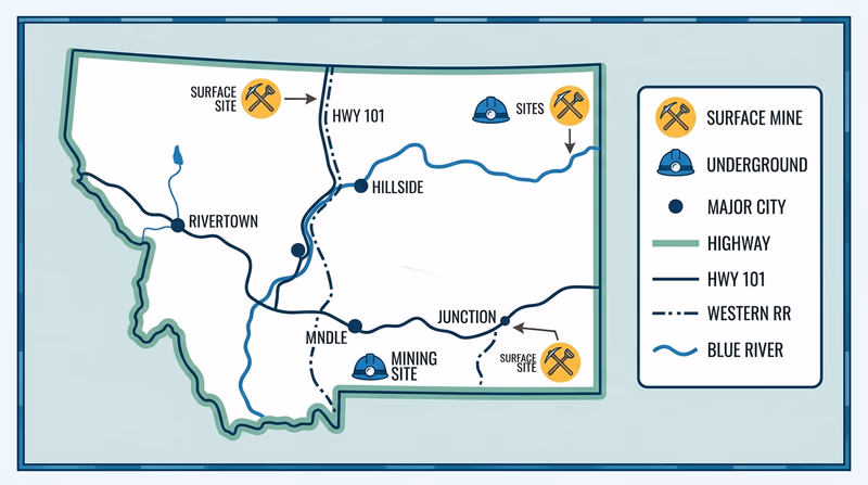
Start with a paper map or digital map of your state. If your state has only a few mining operations, use a broader region instead. The requirement allows that. Your goal is to build a map that tells a story, not just scatter five dots randomly.
What to mark on your map
A good mining map includes more than the mine name. For each of your five locations, add enough notes that your counselor can see what kind of operation it is and why it matters.
What each mine entry should include
Capture the same details at all five locations
- Mine or operation name: Write the specific name if you can find it.
- Location: Mark it clearly on your map.
- Resource: Note what is mined or processed there.
- Type of operation: Identify whether it is surface or underground.
- Transport connections: Notice whether it sits near a highway, rail line, river, or port.
- Use of the resource: Explain where the material likely goes next.
You may find that your five operations are very different. One might be a limestone quarry near a growing city, because crushed stone is heavy and expensive to move far. Another might be a metal mine in a remote area because the ore body is tied to local geology. A third might be a processing or crushing site placed near a rail line so the material can move in bulk.
Surface or underground?
This part of the requirement asks you to classify each operation. A surface mine removes material from open pits, strip mines, quarries, or gravel pits when the resource is close enough to the surface. An underground mine uses shafts, declines, or tunnels to reach deeper deposits.
Do not guess from the commodity alone. Coal, salt, gypsum, limestone, and metal ores can be mined in different ways depending on depth, thickness, and local conditions. Try to verify the mine type from a trusted description, a company page, a government map, or a local geological survey.
Why cities, roads, railroads, and rivers matter
Mining is as much about logistics as geology. A deposit may be valuable, but the operation still needs fuel, equipment, workers, permits, power, and a practical way to move bulk material. That is why this requirement makes you put transportation and population features on the same map.
- Cities may provide workers, markets, and processing facilities.
- Highways carry equipment, fuel, and shorter-haul loads.
- Railroads are especially important for bulk materials such as coal, stone, and ore concentrate.
- Rivers and ports matter when heavy material can move more cheaply by barge or ship.
When you discuss how each resource is used, connect the use to the location. Limestone near a growing metro area may feed cement plants and road building. Sand and gravel near a river valley may supply construction. Copper or gold operations may be farther from cities but linked to roads and processing chains.
How to talk through your findings
Your counselor conversation will go better if you organize your map into a short presentation. Move site by site and explain what you found.
🎬 Video: Mining For Beginners - How Does a Metals and Mineral Mine Work? — Energy and Mining Innovation — https://www.youtube.com/watch?v=wsAzlmz5dso
Once you know where mines are and what they produce, the next question is obvious: how do miners work safely in such demanding places? That is where you are headed next.