Req 4 — The Shape of the Seafloor
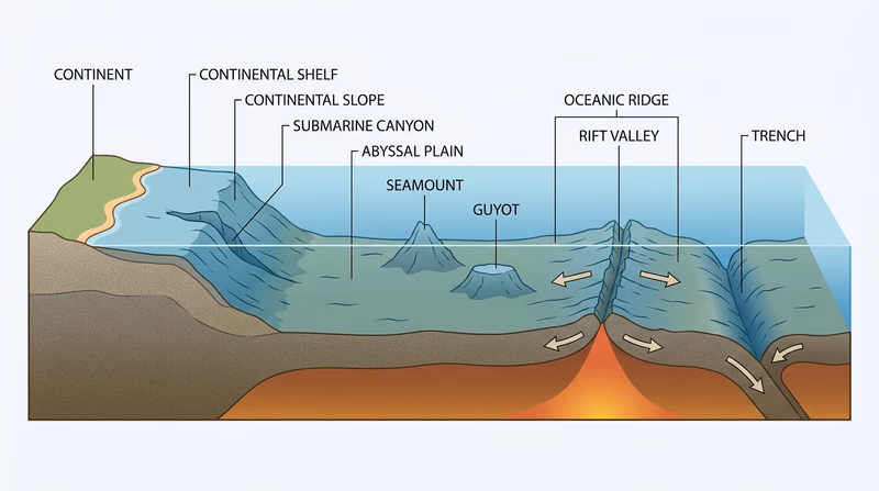
This requirement starts with a drawing because oceanography becomes much easier once you can picture the seafloor. Your cross-section should show the coast, shallow continental edge, steep drop-off, broad deep basin, and major underwater mountains and valleys.
Diagram of Sea Floor (website) A labeled seafloor diagram that helps you place each underwater feature in the right relative position. Link: Diagram of Sea Floor (website) — https://www.visualdictionaryonline.com/earth/geology/ocean-floor.php🎬 Video: How Deep Does the Ocean Go? (video) — https://youtu.be/mAwfTahzbtw
🎬 Video: How Deep the Ocean REALLY Is (video) — https://youtube.com/shorts/DZ9v54D4mZ8?si=l4pnMMCRDzgxQOpF
Building Your Cross-Section
A strong drawing does not need to look artistic. It needs to be clear.
Start at land and move outward:
- coastline and shallow nearshore water
- continental shelf
- continental slope
- deep basin with an abyssal plain
- extra features such as trench, ridge, rift valley, seamount, guyot, and canyon
A seamount is an underwater mountain. A guyot is a flat-topped seamount, usually worn down near sea level long ago and then carried lower. An oceanic ridge is a long underwater mountain chain, often with a central rift valley where tectonic plates pull apart. A submarine canyon cuts into the continental margin. A trench is a very deep, narrow depression where one plate sinks below another.
Requirement 4a: Continental Shelf
The continental shelf is the shallow, gently sloping submerged edge of a continent. Even though it is underwater, it is still part of the continent itself. Shelves are often rich fishing areas because sunlight reaches the water, nutrients can mix in, and life is abundant.
What to show on your drawing
Draw the continental shelf as the broad, shallow platform just offshore before the steep drop begins.
Requirement 4b: Continental Slope
The continental slope is the steeper region beyond the shelf. It marks the transition from shallow continental edge to deep ocean basin. On your drawing, it should look like the part where the seafloor angles downward much more sharply.
What to show on your drawing
Make the slope noticeably steeper than the shelf so the difference is easy to see.
Requirement 4c: Abyssal Plain
The abyssal plain is a broad, deep, relatively flat part of the ocean floor. “Flat” is relative — it is still deep, dark, and huge — but compared with mountains, ridges, and trenches, it is one of the smoothest large regions on Earth.
What to show on your drawing
After the continental slope, draw a wide flatter section in the deep ocean basin.
Feature Placement Guide
Where each major seafloor feature usually belongs
- Shelf: shallow and near the coast.
- Slope: steep drop beyond the shelf.
- Abyssal plain: broad deep basin.
- Canyon: cut into the shelf or slope.
- Oceanic ridge: raised mountain chain in the deep ocean.
- Rift valley: depression running along some ridges.
- Trench: deepest narrow low point.
Comparing Ocean Depths and Mountain Heights
This part surprises many people. The tallest mountains on land and the deepest trenches in the ocean are in the same general scale. Mount Everest rises about 29,000 feet above sea level. The Mariana Trench reaches deeper than 36,000 feet below sea level. That means parts of the ocean are deeper than Everest is tall.
Next you will shift from landforms to the chemistry of seawater itself.