Introduction & Overview
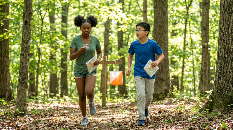
Somewhere in a forest, an orange-and-white flag hangs from a wooden stake. Dozens of competitors are racing to find it — but there is no trail to follow. The only tools they carry are a map, a compass, and their own wits. This is orienteering: the sport where your brain is the engine and the wilderness is the course.
Orienteering teaches you to read the land itself — ridgelines, stream crossings, vegetation boundaries — and translate those features between the real world and a detailed map. It is one of the few merit badges where every skill you learn is immediately testable: take a bearing, follow it through the woods, and either you find the control marker or you don’t. No faking it.
Then and Now
Then
In 1897, a Swedish military officer named Ernst Killander organized what is considered the first orienteering competition near Stockholm. The Swedish military had used cross-country navigation exercises for decades, but Killander saw something more — a way to make land navigation exciting enough that civilians would want to practice it too. The idea worked. By the 1920s, orienteering clubs had spread across Scandinavia, and the invention of affordable compasses by the Silva company in 1933 made the sport accessible to everyone, not just soldiers with military-grade equipment.
The sport jumped to the rest of Europe in the 1950s and reached North America in the 1960s, when Björn Kjellström (one of the Silva compass inventors) began promoting it in the United States. The first U.S. orienteering championships were held in 1970.
Now
Today, orienteering is practiced in over 80 countries, with the International Orienteering Federation (IOF) overseeing world championships in foot, mountain bike, ski, and trail orienteering. Modern orienteering maps are extraordinarily detailed — printed at 1:10,000 or 1:15,000 scale, they show individual boulders, fence corners, and even distinct tree types. Electronic punching systems have replaced the old paper punch cards, letting competitors record their visits to control points with a quick tap of a finger stick.
In an age where GPS can guide you anywhere, orienteering is more relevant than ever. Search-and-rescue teams, wildland firefighters, and backcountry guides all rely on map-and-compass skills when batteries die, signals drop, or satellites fail. The ability to navigate without technology is not a relic — it is a lifeline.
Get Ready!
Kinds of Orienteering
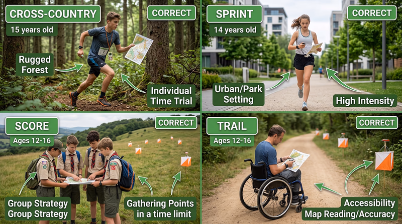
Cross-Country (Foot) Orienteering
The classic format. Competitors visit a set of control points in a specific order, choosing their own route between each one. Courses range from 2 to 12 kilometers through forests, fields, and varied terrain. This is the format you will encounter most often at local events and the one required in Requirement 7.
Score Orienteering
Instead of visiting controls in order, you get a time limit (usually 60–90 minutes) and a map full of control points, each worth different point values. Harder-to-reach controls are worth more. You decide which ones to pursue based on how fast you can navigate. Go over the time limit and you lose points — so clock management matters as much as compass work.
Sprint Orienteering
Held in parks, college campuses, or urban areas, sprint courses are short (2–4 km) but demand fast decision-making. Controls may be tucked behind buildings, along stairways, or inside park features. Races typically last 12–20 minutes. If you like intensity and quick thinking, sprint orienteering is worth trying.
Trail Orienteering
Designed for accessibility, trail orienteering tests map-reading precision rather than speed. Competitors follow a marked trail and must identify which of several flags at each control site is the correct one based on the map. This format welcomes participants of all physical abilities.
Night Orienteering
Same concept, but after dark. Competitors carry headlamps and navigate by compass bearing and pace count, since visibility is limited. Reflective markers on controls help, but finding them requires precise navigation. Night orienteering sharpens your skills dramatically because you cannot rely on distant landmarks.
Ski Orienteering
Popular in Scandinavia and anywhere with reliable snow, ski orienteering combines cross-country skiing with navigation. Competitors navigate a network of ski tracks and must choose the fastest route — which is not always the shortest one on the map.