Req 4a — Terrain Features
A trail map tells you where the paths are. A topographic map tells you what the land looks like — every hill, valley, cliff, and saddle, all represented by brown contour lines on a flat sheet of paper. Learning to read those lines is like learning a new language, and once you are fluent, you can “see” the terrain from the map before you ever set foot on it.
How Contour Lines Work
A contour line connects all points at the same elevation. If you walked along a contour line, you would neither climb nor descend — you would stay perfectly level. The contour interval (stated in the map legend) tells you the elevation difference between adjacent lines. On a typical USGS topographic map, the interval might be 10, 20, or 40 feet.
The key rules:
- Lines close together = steep terrain. When contour lines are packed tightly, the elevation changes rapidly over a short distance.
- Lines far apart = gentle slope. Wide spacing means gradual terrain.
- Lines never cross. Each line represents one elevation. The only exception is an overhanging cliff, which is extremely rare on standard maps.
- Every fifth line is bold. These index contour lines are labeled with their elevation, making it easy to count up or down.
Five Essential Terrain Features
Your counselor will ask you to identify five. Here are the features every orienteer needs to recognize, both on the map and on the ground:
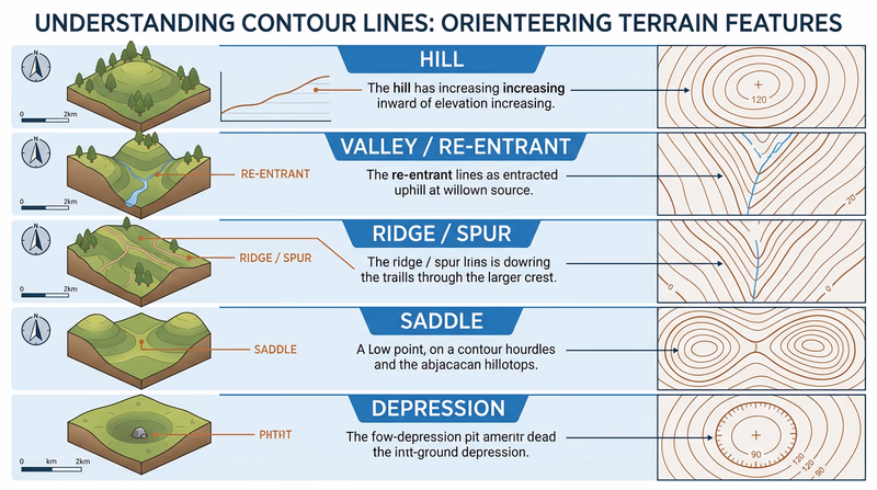
Hill (or Summit)
On the map: concentric contour circles, with elevation increasing toward the center. The innermost ring is the highest point. On the ground: you see a rise of land with slopes falling away in all directions.
Valley (or Re-entrant)
On the map: contour lines form U-shapes or V-shapes pointing uphill (toward higher elevation). On the ground: a low area between ridges where water would naturally flow. In orienteering, small valleys (called re-entrants) are common control point locations.
Ridge (or Spur)
On the map: contour lines form U-shapes or V-shapes pointing downhill (toward lower elevation) — the mirror image of a valley. On the ground: a narrow, elevated spine of land extending outward from a hill.
Saddle (or Col)
On the map: an hourglass shape where contour lines from two adjacent hills nearly touch, with lower ground in between. On the ground: the low point on a ridge between two summits — like the seat of a saddle.
Depression
On the map: closed contour loops with small tick marks (hachures) pointing inward, toward lower ground. On the ground: a low spot or pit — the opposite of a hill.
More Features Worth Knowing
Beyond the five you need for this requirement, experienced orienteers learn to spot these features quickly:
- Cliff — Represented by a black line or thick brown contour bundle, cliffs are steep vertical faces. On orienteering maps, they are marked with a specific black symbol.
- Knoll — A small hill, often just one or two contour lines. Knolls are frequent control locations.
- Terrace (or bench) — A flat area partway up a slope, shown by wider contour spacing interrupting a steep section.