Req 4b — Map Symbols
Contour lines tell you the shape of the land. Map symbols tell you everything on the land — roads, rivers, buildings, vegetation, and boundaries. A topographic map uses a standardized symbol system so that anyone, anywhere, can read any map without a tutorial. Your job for this requirement is to recognize at least 10 of these symbols and know what they represent.
The Five Color Groups
USGS topographic maps organize symbols by color, and each color represents a category:
| Color | Represents | Examples |
|---|---|---|
| Brown | Terrain / elevation | Contour lines, spot elevations, sand, cuts, fills |
| Blue | Water | Rivers, lakes, streams, springs, swamps, canals |
| Green | Vegetation | Forest cover, orchards, scrub, vineyards |
| Black | Human-made features | Buildings, roads, trails, railroads, boundaries, labels |
| Red | Important roads & survey | Major highways, land survey lines, built-up areas |
Some modern maps add purple for features updated from aerial photography since the last full survey revision.
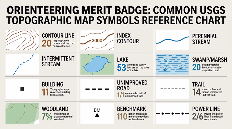
Symbols You Should Know
You need 10 for your counselor. Study these and be able to point them out on a real map:
- Contour line (brown) — A line connecting points of equal elevation. You learned these in Req 4a.
- Index contour (brown, bold) — Every fifth contour line, drawn heavier and labeled with elevation.
- Perennial stream (blue, solid line) — A waterway that flows year-round.
- Intermittent stream (blue, dashed line) — A waterway that flows only seasonally.
- Lake or pond (blue, solid fill) — Standing water body.
- Swamp or marsh (blue, horizontal line pattern with vegetation tufts) — Wetland areas.
- Building (black, small square or rectangle) — Individual structures.
- Unimproved road (black, parallel dashed lines) — Unpaved road or track.
- Trail (black, single dashed line) — Foot or horse trail.
- Woodland (green tint area) — Forested or densely vegetated area.
- Cleared land (white area within green) — Open fields surrounded by forest.
- Benchmark (black triangle with “BM” and elevation) — A surveyed point with precisely known elevation.
- Church (black square with cross) — A church with a prominent steeple visible as a landmark.
- Power line (black, dashed line with dots) — Overhead electrical transmission line.
- Railroad (black, line with cross-ties) — Active or abandoned rail line.
USGS vs. Orienteering Map Symbols
If you are coming from USGS topo maps and then encounter an orienteering map for the first time, the symbols will look different. Orienteering maps follow the International Specification for Orienteering Maps (ISOM) standard, which uses a different color scheme and symbol set optimized for navigation at a run:
| Feature | USGS Map | Orienteering Map |
|---|---|---|
| Dense forest | Green tint | Dark green (slow running) |
| Open forest | White | White (fast running) |
| Open ground | White or no tint | Yellow |
| Marsh | Blue pattern | Blue horizontal stripes |
| Boulder | No standard symbol | Black dot or circle |
| Fence | Varies | Black line with cross marks |
Understanding both systems will help you as you progress from studying USGS topo maps in the classroom to using orienteering maps in competition.
USGS Topographic Map Symbols — Official Reference The complete USGS reference sheet showing all standard topographic map symbols. Print this out and use it while studying.