Req 4c — Magnetic Declination
Here is a fact that surprises most beginners: your compass does not point to the North Pole. It points to the Earth’s magnetic north pole, which is located in a different place — currently in the Canadian Arctic, roughly 500 miles from the geographic (true) North Pole. The angular difference between true north and magnetic north is called declination, and ignoring it is the fastest way to get lost.
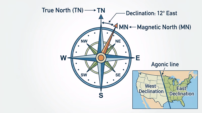
True North vs. Magnetic North
- True north (also called geographic north) is the direction toward the geographic North Pole — the top of the Earth’s axis of rotation. Maps are drawn with true north at the top.
- Magnetic north is the direction your compass needle points. It shifts over time because the Earth’s magnetic field is generated by moving molten metal in the outer core.
The angle between these two directions, measured from your location, is magnetic declination. It varies depending on where you are on Earth.
East and West Declination
- East declination means magnetic north is east of true north. Your compass needle points slightly right of where the map says north is. This occurs along the East Coast and across the eastern United States.
- West declination means magnetic north is west of true north. Your compass needle points slightly left of true north. This is common on the West Coast.
- Zero declination (agonic line) runs roughly through the Mississippi Valley, where true north and magnetic north happen to align. On this line, no correction is needed.
Why Declination Matters
A bearing taken from a map uses true north. A bearing read from your compass uses magnetic north. If the declination in your area is 10° east and you ignore it, every bearing you follow will be off by 10°. That sounds small, but over distance the error compounds rapidly.
How to Correct for Declination
There are two approaches:
Method 1: Adjust the Bearing Mathematically
After taking a bearing from the map (a “true” bearing), convert it to a magnetic bearing before following it with your compass:
- East declination: Subtract the declination from your map bearing.
- West declination: Add the declination to your map bearing.
A common mnemonic: “East is least (subtract), West is best (add).” This refers to converting from true to magnetic. When going the other direction (field bearing to map bearing), you reverse the operation.
Method 2: Set the Declination on Your Compass
Many orienteering compasses have an adjustable declination correction — a small screw or mechanism that offsets the orienting arrow by the declination value. Once set, all your readings are automatically corrected and you never need to do the math in the field. This is the preferred method for most orienteers.
Method 3: Draw Magnetic North Lines on Your Map
Instead of correcting every bearing, you can draw magnetic north-south lines on the map itself (you will learn this in Req 4d). When you align the orienting lines with these lines instead of the map’s grid lines, the correction is built in.
NOAA Magnetic Declination Calculator Enter your location and get the current magnetic declination value. Updated regularly as the magnetic field shifts.