Req 6a — Control Description Symbols
When you arrive at a control circle on your orienteering map, you know the general area — but the control flag could be on a boulder, behind a tree, next to a stream junction, or in a depression. The control description symbols are an international pictorial language that tells you the exact feature and its precise location, without using any written words. This system, maintained by the International Orienteering Federation (IOF), works the same whether you are competing in Sweden, Japan, or Ohio.
Why Symbols Instead of Words?
Orienteering is an international sport. A description sheet written in Finnish would not help a Brazilian competitor. The IOF symbol system eliminates the language barrier — every orienteer in the world reads the same pictographs the same way.
The Eight Columns
Control description symbols are organized into a table with up to eight columns. Each column has a specific purpose:
| Column | Purpose | Example |
|---|---|---|
| A | Control number (sequence) | 1, 2, 3… |
| B | Control code (marker ID) | 101, 205, 47 |
| C | Which of similar features | Northern, middle, eastern |
| D | Feature (what the control is on) | Boulder, re-entrant, path crossing |
| E | Appearance / size | Large, small, shallow, deep |
| F | Dimensions | 2m × 3m, height 5m |
| G | Position relative to feature | North side, foot, bend |
| H | Other information | First aid, refreshment, manned |
For this requirement, you need to identify 20 symbols and explain what they mean. Focus on the most common ones — these are the symbols you will encounter at nearly every event.
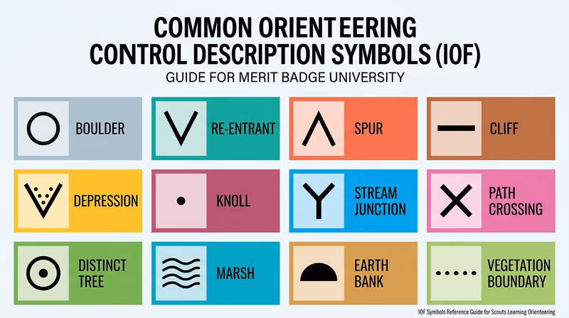
Common Control Description Symbols to Learn
Landform Features (Column D)
These symbols describe the terrain feature where the control is placed:
- Terrace — A flat area on a slope, like a natural shelf.
- Spur — A small ridge projecting from a larger slope.
- Re-entrant — A small valley or indentation in a hillside.
- Earth bank — A steep, distinct change in ground level.
- Quarry — An excavated area, typically with steep sides.
- Depression — A hollow or pit in the ground.
- Small depression — A smaller version, often just 1–2 meters across.
- Hill / Knoll — A distinct rise in the ground.
- Cliff — A steep rock face.
- Boulder — A distinct large rock.
- Boulder field — An area covered with boulders.
Water Features (Column D)
- Lake — A body of standing water.
- Pond — A small body of standing water.
- Stream — Flowing water.
- Marsh — Wetland area.
- Spring — A point where water emerges from the ground.
Vegetation Features (Column D)
- Open land — Field, meadow, or clearing.
- Distinct tree — A single tree that stands out from its surroundings.
- Vegetation boundary — The line where one type of vegetation meets another (e.g., forest edge).
Human-Made Features (Column D)
- Path or trail crossing — Where two paths intersect.
- Road — A wider, more developed path.
- Fence — A fence, wall, or similar linear barrier.
- Building — A structure.
- Ruin — Remains of a structure.
Position Symbols (Column G)
- North side — Control is on the north side of the feature.
- Southeast corner — Control is at the SE corner.
- Upper part — Control is on the upper portion.
- Lower part / Foot — Control is at the base.
- Between — Control is between two features.
- Bend / Corner — Control is at a bend in a linear feature.
- Junction / Crossing — Control is where features meet.