Req 8 — Setting Up a Course
This requirement asks you to shift from competitor to course designer. You choose one of two options:
- Option A: Set up a cross-country course at least 2,000 meters long with at least five control markers
- Option B: Set up a score orienteering course with at least 12 control points and a 60-minute time limit
Both options require a master map and a control description sheet. Read through both options below and choose the one that best fits your situation, your available terrain, and the resources you have.
Option A — Cross-Country Course
A cross-country course visits controls in a fixed sequence. Competitors must find them in order. Designing one teaches you to think about leg difficulty, route choice, and how terrain creates navigation challenges.
Planning the Course
Choose your venue. A park, camp property, or Scout reservation with varied terrain works best. You need features — hills, streams, trails, clearings, boulders — to place controls on. A flat, featureless field will not create an interesting course.
Obtain a map. Use a USGS topographic map, an existing orienteering map if one exists for the area, or create a simplified map. Draw magnetic north lines on it (your work from Req 4d applies here).
Select control locations. For each control, pick a distinct, identifiable terrain feature — something you can describe unambiguously on the control description sheet. Place controls at features like:
- Trail junctions or bends
- Stream crossings or junctions
- Hilltops, saddles, or re-entrants
- Boulders, clearings, or vegetation boundaries
- Buildings or ruins
Plan the legs. Arrange controls so that the total course distance is at least 2,000 meters (2 km). Vary the leg difficulty — some should be along obvious handrails, others should require compass bearings through trickier terrain. The course should flow logically and avoid dangerous areas.
Assign control codes. Give each control a unique number (e.g., 101–105) that does not match its sequence number.
Setting Up in the Field
- Hang control markers (orange-and-white flags or homemade equivalents) at the exact location described on the sheet. Hang them at eye level and visible from at least a few meters away.
- Mark the control code clearly on each marker.
- Verify with a buddy. Have someone else use your map and descriptions to find each control. If they struggle, adjust.
Option B — Score Course
A score course has no required order. Competitors choose which controls to visit within a time limit. Harder-to-find or more distant controls are worth more points. Designing one teaches you about risk-reward tradeoffs and terrain difficulty assessment.
Designing the Point Values
Assign point values based on difficulty:
| Difficulty | Points | Typical Location |
|---|---|---|
| Easy | 10–20 | Near trails, obvious features, close to start |
| Moderate | 30–40 | Requires compass bearing, farther from trails |
| Hard | 50–60 | Off-trail, requires precise navigation, distant |
Make sure the total points available exceed what anyone could reasonably collect in 60 minutes. This forces strategic choices.
Penalty for Overtime
Standard score orienteering deducts points for exceeding the time limit — typically 10 points per minute over. State this rule clearly in the event briefing.
Preparing the Master Map and Control Description Sheet
Both options require these two documents:
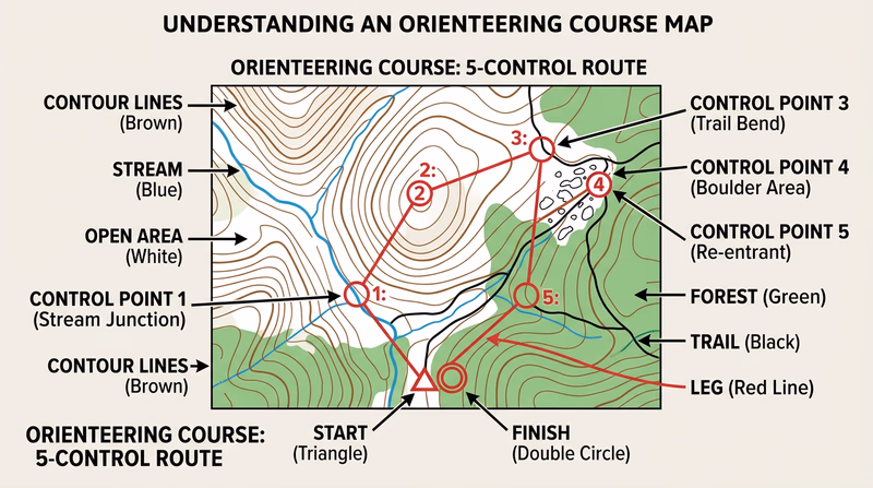
Master Map
The master map shows:
- Start location (marked with a triangle)
- All control locations (circles with numbers)
- Connecting lines between controls (for cross-country) or all controls scattered (for score)
- Finish location (double circle)
Draw this on a clean copy of your base map. Make copies for competitors.
Control Description Sheet
Create a sheet following the IOF format you studied in Req 6b. Each row describes one control using the eight-column format. Every control needs at minimum:
- Column A: Sequence number (cross-country) or point value (score)
- Column B: Control code
- Column D: Feature symbol
- Column G: Position on feature
Course Design Quality Check
Verify before opening the course to competitors
- Total distance is at least 2,000m (Option A) or at least 12 controls exist (Option B): Meets the minimum requirement.
- Every control is on a distinct, identifiable feature: No ambiguous placements.
- Control descriptions match actual field placement: Walk and verify each one.
- Control codes do not match sequence numbers: Prevents guessing.
- Course avoids hazards: No cliff edges, deep water, private property, or road crossings.
- Map has magnetic north lines drawn: Competitors can navigate accurately.
- Master map is clean and legible: All symbols, circles, and lines are clear.