Req 3 — Reading the Map Like a Searcher
This requirement is about turning a flat sheet of paper or a phone screen into a search picture. Searchers use maps to understand where the subject was last seen, how far that person could travel, what terrain might slow or attract them, and which boundaries can help contain the search.
- Req 3a: Read the most important information printed on the map.
- Req 3b: Record one location in several coordinate systems.
- Req 3c: Orient the map, take a bearing, and estimate distance and terrain.
- Req 3d: Mark a place last seen and think like a planner about containment.
In the Orienteering merit badge, you build many of these navigation habits in a sport setting. In SAR, the same skills help teams decide where to look first.
Requirement 3a
The 5 D’s help you read the map before you start walking.
| D | What to look for | Why searchers care |
|---|---|---|
| Date | When the map was made or updated | Roads, trails, and buildings may have changed. |
| Description | What area and map type it shows | You need to know whether it is a trail map, topo map, or another format. |
| Details | Symbols, contour lines, water, roads, structures | These clues shape search planning and route choices. |
| Direction / Declination | North references and magnetic declination | Bearings only work if map and compass agree on north. |
| Distance | Scale bar and contour spacing | This tells you how far subjects or teams can actually move. |
Requirement 3b
Latitude and longitude describe a position on the earth using angular measurement. US National Grid uses letters and numbers in square grid form, which many responders find faster to communicate and plot during land operations.
Altitude adds the vertical piece. Two points can share similar map positions but feel very different on the ground if one is deep in a drainage and the other is on a ridge.
A good explanation sounds something like this: latitude and longitude are a global geographic system, while USNG is a grid reference system that breaks the map into easier-to-measure squares. Both can describe the same place, but they look and sound different when spoken over a radio.
Requirement 3c
Orienting the map means turning it so the map matches the real world around you. Once the map is aligned, bearings and terrain features make much more sense.
When you estimate the route between two points, do more than measure straight-line distance. Ask:
- Is there a creek crossing?
- Does the route climb sharply?
- Are there trails, roads, or drainages that could attract a lost person?
- Would brush, cliffs, or swamp slow the team down?
🎬 Video: In and Out Navigation: The Easiest Way to Use a Compass — Coalcracker Bushcraft — https://www.youtube.com/watch?v=mZF-RKJcODQ
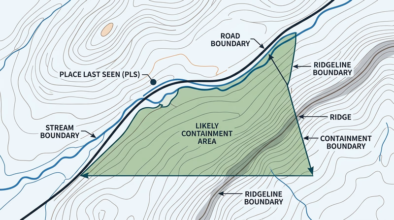
Requirement 3d
This is where map reading becomes SAR planning. A place last seen is your starting point. From there, planners think about where the subject could go and what boundaries might stop, channel, or reveal that movement.
Natural boundaries might include rivers, ridges, lakes, cliffs, or canyon walls. Human-made boundaries might include roads, fences, rail lines, neighborhoods, campgrounds, or trailheads.
The merit badge pamphlet explains confinement as creating a search perimeter that likely contains the subject. On page 67, it describes plotting the PLS or LKP, then building a search circle and looking for roads, trails, streams, or ridges that can serve as boundaries.
With the map picture in mind, you are ready to see how SAR missions organize people and decisions through the Incident Command System.