Soil and Water Conservation Merit Badge — Complete Digital Resource Guide
https://merit-badge.university/merit-badges/soil-and-water-conservation/guide/
Introduction & Overview
The ground under your boots is doing more work than it looks like. Healthy soil grows food, anchors forests, stores water, and filters rain before it reaches streams and wells. Soil and Water Conservation helps you see how land, plants, weather, and people are all tied together.
This badge is about more than dirt and puddles. It teaches you how erosion starts, how watersheds connect communities, and how smart choices on land can protect water far downstream. Once you understand those connections, you start noticing them everywhere — at camp, at school, on farms, and in your own neighborhood.
Then and Now
Then — Learning the Hard Way
For a long time, many people treated soil as if it would always stay put and always stay fertile. They plowed steep hillsides, cleared too much vegetation, and let streams carry the loosened soil away. In the 1930s, the Dust Bowl showed the United States what can happen when drought, wind, and poor land use combine. Entire fields blew away, farms failed, and huge dust storms darkened the sky.
That disaster changed the way the country thought about conservation. Farmers, foresters, engineers, and government agencies began developing better ways to protect topsoil, slow runoff, and manage watersheds as connected systems instead of isolated pieces of land.
Now — Protecting Whole Systems
Today, soil and water conservation still matters, but the reasons are even bigger. Healthy soils help crops grow, store carbon, reduce flooding, and support insects, microbes, and wildlife. Protected watersheds help supply clean drinking water, keep reservoirs from filling with sediment, and reduce the cost of treatment for cities downstream.
Modern conservation uses both old and new tools: cover crops, riparian buffers, contour farming, wetland restoration, soil surveys, satellite images, and water-quality monitoring. The goal is the same as it was during the first big conservation efforts — keep soil where it belongs and keep water clean enough to use.
Get Ready!
You are about to start looking at land the way a conservationist does. Bring curiosity, not just answers. The best Scouts in this badge pay attention to puddles, slopes, plant cover, muddy ditches, streambanks, and the way water moves after a storm.
Kinds of Soil and Water Conservation
Soil Protection on Working Land
On farms, ranches, and timberlands, conservation means keeping valuable topsoil in place while still producing food, fiber, and other resources. That can include planting cover crops, rotating grazing, leaving crop residue on the field, or farming across a slope instead of straight up and down it.
Watershed Protection
A watershed is all the land that drains to the same place. Conservation at this scale focuses on slowing runoff, keeping streams shaded, protecting wetlands, and reducing pollution before it enters the water. A small mistake uphill can become a big problem downstream.
Groundwater and Drinking Water Protection
Many communities depend on wells and aquifers. Conservation here means protecting recharge areas, limiting contamination, and understanding how land uses above ground affect water stored below ground.
Erosion and Sediment Control
Construction sites, trails, streambanks, and bare slopes can all lose soil quickly. Silt fences, mulch, terraces, grass cover, and retaining vegetation are all ways to keep soil from washing away and clogging nearby water.
Community Restoration Projects
Not every conservation job is huge. Planting trees, reseeding bare patches, fixing drainage, mapping problem spots, and helping with a local cleanup are all practical ways Scouts can improve the land around them.
You have the big picture. Now it is time to start with the material at the center of the badge: soil itself, how it forms, and what makes it fertile.
Req 1 — Soil Fundamentals
This requirement builds your soil vocabulary before you start talking about erosion and conservation. You will learn three connected ideas:
- what soil is and how it forms
- how sandy, silty, and clay soils behave differently
- which nutrients make soil fertile and how people replace them
Requirement 1a
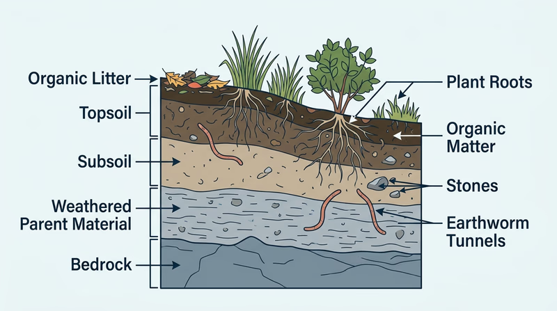
Soil is not just crushed rock. It is a living mixture of mineral particles, organic matter, water, air, and countless tiny organisms. Good soil has spaces between particles, so roots can grow and water can move. It also contains dead plant material and living organisms such as fungi, insects, worms, and bacteria.
Soil forms slowly. First, parent material such as bedrock or loose sediment breaks down through weathering. Weathering can happen when water freezes and expands in cracks, when wind and flowing water grind rock into smaller pieces, or when roots and chemicals slowly weaken the rock. At the same time, leaves, roots, and other once-living material decay and add organic matter called humus.
Over many years, those materials sort themselves into layers called soil horizons. Near the surface, the soil is usually darker because it contains more organic matter and more living activity. Deeper down, the soil is lighter, denser, and closer to the original material it formed from.
The Dirt on Soil (video) A short introduction to soil as a living system, not just loose dirt. It is a good way to hear the main idea in plain language before you explain it yourself. Link: The Dirt on Soil (video) — https://www.pbs.org/video/soil-video-short-zfxcrn/🎬 Video: Formation of Soil (video) — https://youtu.be/YZ_D1ANF-E0?si=6lNRN2ODpZ7pe872
Requirement 1b
The three basic soil particle types are sand, silt, and clay. They differ mainly by particle size, and that size changes how the soil feels and behaves.
| Soil type | Particle size | Feel | Water behavior | Common strengths | Common problems |
|---|---|---|---|---|---|
| Sand | Largest | Gritty | Drains quickly | Good aeration, easy to work | Dries out fast, nutrients wash out |
| Silt | Medium | Smooth, almost flour-like | Holds more water than sand | Often fertile, holds nutrients well | Can erode easily |
| Clay | Smallest | Sticky when wet, hard when dry | Drains slowly | Holds water and nutrients well | Compacts easily, poor drainage |
Most real soils are mixtures. A soil with a balanced mix of sand, silt, and clay is called loam, and it is often excellent for growing plants because it holds moisture while still letting roots breathe.
A simple way to compare the three is to imagine a rainstorm. Water sinks fast into sand, moves moderately through silt, and may puddle on clay. That is why the same storm can leave one area dusty the next day and another area muddy for a week.
🎬 Video: Types of Soil (video) — https://youtu.be/G0JcVe_-yu0?si=WuJclD25JrEA4AMg
Requirement 1c
The three main plant nutrients are nitrogen (N), phosphorus (P), and potassium (K). You often see them listed on fertilizer labels as the N-P-K numbers.
- Nitrogen helps plants make leafy green growth.
- Phosphorus supports root growth, flowering, and seed production.
- Potassium helps with overall plant health, water balance, and disease resistance.
Plants remove nutrients from the soil as they grow. Harvesting crops removes even more, because the nutrients leave the field with the grain, fruit, hay, or vegetables. Conservation means thinking about how to return those nutrients instead of mining the soil year after year.
Ways to put nutrients back include:
- compost and manure, which add both nutrients and organic matter
- cover crops, especially legumes, which can help add nitrogen
- crop rotation, which keeps one crop from using the same nutrients over and over
- commercial fertilizers, used carefully and in the right amount
- mulching and leaving plant residue, which helps organic matter return to the soil
🎬 Video: The Three Most Important Nutrients for Plant Growth (video) — https://youtu.be/zgppw6fJOlw
In gardening, farming, and habitat work, soil fertility and water quality are tied together. That same connection shows up again in Req 6, where you will look at water pollution.
You know what healthy soil is made of. Next, look at what happens when soil stops staying where it belongs.
Req 2 — Understanding Soil Erosion
Erosion is what happens when soil starts moving instead of staying in place. This requirement covers four parts of that story:
- what erosion is
- why it matters to people as well as land
- the main kinds you are likely to see
- how to document real examples with pictures or drawings
Requirement 2a
Soil erosion is the wearing away and movement of soil by water, wind, ice, or gravity. The key idea is movement. Soil is not just breaking apart — it is being carried from one place to another.
That matters most when the soil being lost is topsoil, the dark upper layer rich in organic matter and nutrients. Topsoil supports plant growth, absorbs water, and helps hold ecosystems together. When it washes or blows away, the land becomes less productive and more vulnerable to more erosion.
🎬 Video: Soil Basics: Erosion (video) — https://youtu.be/DRkw5kOZsc8?si=Gq7gY0l0JDMjxhFD
Requirement 2b
Erosion is important because it damages land twice. First, it removes useful soil from the place where you need it. Second, it drops that soil somewhere else as sediment, which can clog ditches, cover stream bottoms, fill reservoirs, and muddy drinking-water sources.
Even if you do not live on a farm, erosion affects you. It can:
- raise the cost of food by reducing farm productivity
- make trails, roads, and campsites muddy or damaged
- increase flooding by reducing the soil’s ability to absorb rain
- hurt fish and insects when sediment clouds streams
- make communities spend more money on stormwater and water treatment
After a heavy rain, look at the nearest storm drain or roadside ditch. If the runoff is brown, that color is often soil that used to be somewhere uphill.
🎬 Video: Why Soil Conservation is Important to Human Agriculture? (video) — https://youtu.be/BuEdKEh2buI
Requirement 2c
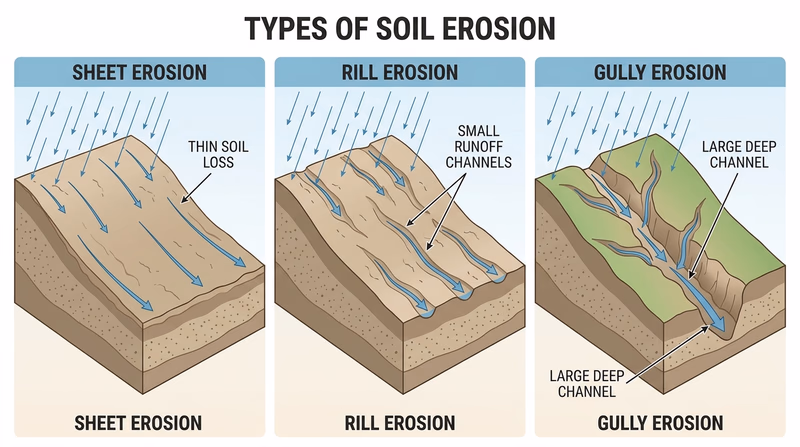
Three common kinds of erosion are sheet erosion, rill erosion, and gully erosion.
Sheet erosion
Sheet erosion is the thin, even removal of soil across a wide area. It can be hard to notice because it does not always leave a dramatic scar. But it steadily removes topsoil from fields, yards, and bare slopes.
Rill erosion
Rill erosion happens when runoff cuts many small channels into the soil. These channels are usually shallow enough to step across or smooth out, but they show that water is starting to concentrate and dig into the ground.
Gully erosion
Gully erosion is the large-scale version. Water cuts deep channels that are too large to ignore and too large to fix by simple smoothing. Gullies can make land unsafe to cross and can keep growing with every storm.
A useful way to remember the pattern is: sheet is spread out, rills are small channels, gullies are big channels.
Requirement 2d
This is a field observation job, not an art contest. Your goal is to show that you can recognize real erosion and label what you are seeing.
Good places to look include:
- the edge of a gravel trail after rain
- a bare slope near a parking lot or school field
- streambanks with exposed roots
- muddy construction entrances
- unmulched flower beds or drainage swales
When you take a picture or make a drawing, include clues that help your counselor read it clearly:
- show the slope or direction water moved
- include something for scale, such as a boot or notebook
- label the erosion type
- note what probably caused it, such as bare soil, steep slope, or concentrated runoff
- write one sentence about how it might be corrected
In Req 3, you will switch from spotting problems to explaining solutions.
Req 3 — Erosion-Control Practices
Now that you know how soil is lost, this requirement focuses on how people keep it in place. You will define conservation practices, look at three types of erosion-control methods, and then document real examples you can see or sketch.
🎬 Video: What is Soil Conservation (video) — https://youtu.be/YGu_09HH-Xo
Requirement 3a
Conservation practices are planned actions people use to protect soil, water, plants, and other natural resources. A good conservation practice does not just fix damage after it happens. It changes the way land is managed so damage is less likely to happen at all.
Examples include planting grass on bare ground, farming along the contour of a hill, leaving streamside vegetation in place, rotating grazing, using silt fences at a construction site, or building terraces on steep farmland.
The main goal is usually one or more of these:
- slow water down
- keep soil covered
- hold soil in place with roots or structures
- increase infiltration so less water runs off
- keep sediment out of streams and ponds
Requirement 3b
Here are three strong examples you can describe to your counselor.
Vegetative cover
Grass, shrubs, trees, mulch, and cover crops shield the soil from raindrop impact. Their roots hold particles together, and their leaves and stems slow runoff. The effect is less soil loss, better water absorption, and healthier soil over time.
Contour farming or terraces
On a slope, water naturally wants to speed downhill. Contour rows and terraces interrupt that flow. They slow water down, spread it out, and give it more time to soak in. The effect is less rill and gully erosion and better moisture retention.
Buffers and sediment barriers
Streamside buffers, filter strips, wattles, and silt fences trap moving sediment before it reaches water. Their effect is cleaner runoff, less sediment in streams, and less damage downstream.
A Simple Way to Explain the Effect
Use this sentence pattern with any practice you choose- Name the practice: for example, grass cover, terrace, or buffer strip.
- Say what it changes: it slows water, adds cover, or traps sediment.
- Say what result follows: less erosion, cleaner water, healthier soil, or less flooding.
Requirement 3c
Look for practices that are easy to explain from the picture itself. You want your counselor to be able to say, “Yes, that Scout knows what this practice is doing.”
Good subjects include:
- grass or mulch covering bare soil
- a silt fence on a construction site
- a vegetated ditch or swale
- a streambank with planted shrubs
- contour rows on farmland
- a retention pond catching muddy runoff
For each image or drawing, label three things:
- the practice you are showing
- the erosion problem it helps prevent
- the reason it works
The next requirement zooms out from single slopes and single practices to whole drainage systems: watersheds, river basins, and aquifers.
Req 4 — Watersheds, Basins & Aquifers
This requirement is about reading the landscape. You will define a watershed, trace drainage areas on a contour map, and connect surface water to larger river basins and underground aquifers.
Requirement 4a
A watershed is all the land area that drains water to the same place. That place might be a ditch, creek, pond, river, lake, or estuary. If two raindrops land on opposite sides of a ridge and flow to different streams, they are in different watersheds.
You can think of a watershed like a giant bowl. The ridges and high ground form the edges. Everything inside drains toward a common low point.
🎬 Video: What is a Watershed (video) — https://youtu.be/gVdq4pWUiQM
🎬 Video: Watersheds, Rivers and Floodplains (video) — https://youtu.be/ButQspZX2yA?si=TgRhRG8uoKpe4oS3
🎬 Video: How (and Why) to Find Your Watershed (video) — https://youtu.be/kqwYulqfC9k
Requirement 4b
The smallest watershed on a map is usually the drainage area feeding a tiny stream, draw, or hollow. To outline it, find the low point where water exits the area, then trace the surrounding high ground that would divide runoff from neighboring areas.
A contour map helps because contour lines show elevation. Water flows downhill and crosses contour lines at roughly right angles. Watershed boundaries usually follow ridges, not valleys.
A simple tracing method
- Find the stream or drainage line you want to study.
- Mark the point where water leaves the smallest area you can identify.
- Look uphill on both sides for the ridges.
- Connect the high points so your line stays on the divide between one drainage and the next.
Requirement 4c
This part teaches an important idea: watersheds are nested. A tiny tributary watershed sits inside a larger creek watershed, which sits inside a still larger river watershed.
When you outline the next larger watershed, you are showing how small drainage systems fit into bigger ones. That is why land use on a seemingly small hillside can matter far away. The little stream drains to a bigger stream, and the bigger stream drains to a river.
Requirement 4d
A river basin is a large area of land drained by a river and all its tributaries. In the Soil and Water Conservation pamphlet, the idea is framed this way: all river basins are large watersheds, but not every watershed is large enough to be called a river basin.
That matters because people in one part of the basin are connected to people elsewhere in the basin. Soil washed off fields upstream can become sediment downstream. Fertilizer or waste released near one town can affect water treatment for another town. Forest clearing in the headwaters can change flood risk far away.
🎬 Video: River Basins (video) — https://youtu.be/x7lBi6OaFMo?si=Z2hmQJEjQjmIlQvv
Requirement 4e
An aquifer is a layer of rock, sand, or gravel underground that stores and transmits water. It is not usually an underground lake or cave full of open water. More often, the water sits in tiny spaces between particles or in cracks in rock.
Aquifers matter because many communities use wells as part or all of their drinking-water supply. Aquifers can also feed springs and streams. If an aquifer is polluted, that contamination can be hard and expensive to remove. If groundwater is pumped faster than it recharges, wells can decline.
🎬 Video: What is an Aquifer (video) — https://youtu.be/g7R0yLX0V9E
In the next requirement, you will follow water through the hydrologic cycle and see how vegetation, land use, and industry affect supply and runoff.
Req 5 — The Water Cycle & Runoff
Water is always moving. In this requirement, you will connect the hydrologic cycle to real land-use questions: how water moves through soil, how vegetation changes runoff, and how forests, farms, rangelands, and industry affect usable water supplies.
Requirement 5a
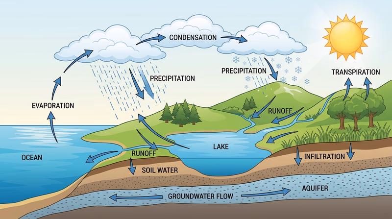
The hydrologic cycle is the continuous movement of water between the land, oceans, atmosphere, plants, and ground. In the pamphlet, it is described as water traveling from the sea through the air by means of clouds, and back to Earth again as precipitation.
A strong drawing should include these labeled parts:
- evaporation from oceans, lakes, rivers, and soil
- condensation forming clouds
- precipitation falling as rain or snow
- runoff moving downhill over land
- infiltration or percolation into soil
- groundwater flow underground
- transpiration from plants back to the air
🎬 Video: The Water (Hydrologic) Cycle (video) — https://youtu.be/FzYjPpxP-Cw
Requirement 5b
Pick two actions you can show clearly and safely. The easiest pair for many Scouts is percolation and capillary action because they are simple to demonstrate with cups, soil, water, and paper materials.
Percolation
Percolation is water moving downward through soil because of gravity. Sandy soil usually percolates faster than clay soil. A basic demonstration is to pour the same amount of water through two containers with different soils and compare how quickly it drains.
Capillary action
Capillary action is water moving upward or sideways through tiny spaces in soil. Plants depend on this movement. You can demonstrate it with a strip of paper towel or with dry soil touching water from below and watching the moisture rise.
Precipitation, evaporation, and transpiration
These are also good choices if you can show them clearly. For example, you might collect rain in a gauge, mark water loss from a shallow pan over time, or place a plastic bag over leaves and watch moisture collect from transpiration.
🎬 Video: Capillary Rise (video) — https://youtu.be/5waNTa2b-yg
🎬 Video: Soil Capillary Action Demonstration (video) — https://youtu.be/0Hcp2UGkbj4?si=7U9FAlP5XbSnUVha
🎬 Video: Soil Percolation Experiment (video) — https://youtu.be/CBmDlbFOZKU
Requirement 5c
Removing vegetation usually makes runoff faster, dirtier, and more damaging. Leaves and stems soften the impact of raindrops. Roots hold soil in place. Plant cover also helps water soak into the ground.
When vegetation is removed:
- less water infiltrates
- more water runs off the surface
- runoff reaches streams faster
- erosion and sediment increase
- flooding risk rises
- stream temperatures can increase if shade is lost
🎬 Video: How Vegetation Protects Soil (video) — https://youtu.be/wa9MTy_lSpY
Requirement 5d
Different land uses affect water in different ways.
Forest
Healthy forests usually improve water quality. Leaf litter and roots increase infiltration, reduce erosion, and help moderate stream flow. But poor logging practices or road building can raise sediment and change runoff.
Range or pasture
Well-managed grazing land can protect soil and water, especially when vegetation cover stays strong. Overgrazing removes cover, compacts soil, and creates bare patches where runoff speeds up.
Farmland
Farmland can either protect or damage usable water supply depending on management. Cover crops, contour farming, buffer strips, and careful fertilizer use help. Bare fields, excessive tillage, and poor drainage management can send sediment and nutrients into waterways.
🎬 Video: Rangeland Management and Water Supply (video) — https://youtu.be/PQf0gdomgGg?si=MNPoiCVV6Cc3QQlQ
Requirement 5e
Industry affects water supply in two main ways: quantity and quality. Some industries use huge amounts of water for cooling, washing, processing, or power generation. That can reduce what is available locally, especially in dry areas. Industry can also affect quality if wastewater, heat, or chemicals are not well controlled.
At the same time, industry can improve its impact through water recycling, efficient equipment, better treatment, and careful monitoring. Many modern facilities work to use less fresh water and discharge cleaner water than in the past.
Reimagining Industrial Water for Sustainable Impact (video) A useful look at how industry can reduce freshwater demand, reuse water, and improve treatment, even though this video must be opened on YouTube instead of embedded here. Link: Reimagining Industrial Water for Sustainable Impact (video) — https://youtu.be/xeTGV3e1QB8?si=rxKeNygqQnzccQd2The next requirement looks at what happens when water quality drops: pollution, wastewater treatment, and the meaning of biochemical oxygen demand.
Req 6 — Water Pollution & Waste Treatment
This requirement moves from water supply to water quality. You will define water pollution, identify common pollution sources, learn the basic stages of waste treatment, and sketch how a complete treatment system works.
🎬 Video: Water Pollution and How We Can Reduce It (video) — https://youtu.be/4Q8dL8RtQM0
🎬 Video: H2-Oh No! Water Pollution 101 (video) — https://www.youtube.com/shorts/mgtpMLsAds0
Requirement 6a
Water pollution means adding substances or energy to water in ways that make the water less safe, less healthy, or less useful. The pollutant might be sediment, sewage, fertilizer, oil, chemicals, trash, harmful bacteria, or even heat.
The key point is not just that something entered the water. It is that the water’s quality changed enough to harm people, wildlife, or normal uses such as drinking, swimming, irrigation, or fishing.
Requirement 6b
Common pollution sources include:
- sediment from erosion — clouds water, covers stream habitat, and often carries attached pollutants
- fertilizer and manure — add excess nutrients that can trigger algae blooms
- sewage and failing septic systems — introduce disease-causing organisms and organic waste
- industrial discharges — may add chemicals, metals, or heat
- oil and fuel leaks — harm aquatic life and contaminate shorelines
- stormwater runoff from streets and parking lots — carries trash, salt, metals, and other pollutants
A strong answer names both the source and the result. For example, fertilizer runoff can lead to algae growth, and when that algae dies, decomposition uses oxygen that fish and aquatic insects need.
Source → Effect
Use this pattern when you explain pollution- Source: Where did the pollutant come from?
- Pathway: How did it get into the water?
- Effect: What changed in the stream, lake, or water supply?
Requirement 6c
These terms are closely connected, so learn them as parts of one system.
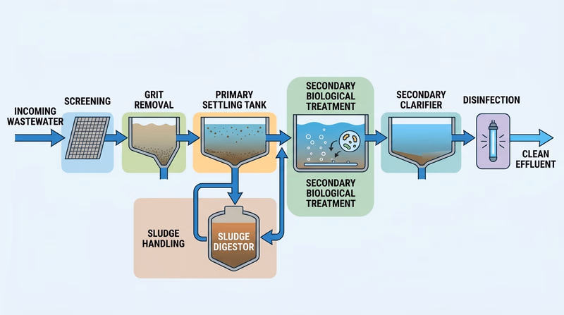
Primary water treatment
Primary treatment is the first major cleanup stage in a wastewater plant. It mainly removes large solids and materials that can settle or float. Screens catch big debris. In settling tanks, heavy solids sink to the bottom and grease or scum rises to the top.
Secondary waste treatment
Secondary treatment goes after dissolved and suspended organic waste that primary treatment does not remove. This stage often uses oxygen and microorganisms to break down that waste. In simple terms, helpful microbes do a lot of the cleanup work.
Biochemical oxygen demand
The pamphlet describes biochemical oxygen demand, or BOD, as the amount of oxygen required to decompose the organic matter present in water. High BOD is a problem because microorganisms use up oxygen while breaking down waste, leaving less oxygen available for fish and other aquatic life.
🎬 Video: How Does Wastewater Treatment Work? (video) — https://youtu.be/cUFKay8VPqo
Requirement 6d
Your drawing does not need to look like an engineering blueprint. It needs to show the main flow and purpose of each stage.
A clear drawing should include:
- incoming wastewater
- screening or grit removal
- primary settling tank
- secondary biological treatment
- secondary clarifier
- disinfection or final cleanup
- treated water leaving the plant
- sludge handling if your counselor wants a fuller picture
Use arrows to show direction of flow, and label each stage with one short note about what it removes or accomplishes.
Req 7a6 gives you a chance to see many of these treatment ideas in action during a site visit.
Req 7 — Choose Two Conservation Projects
This requirement is where the badge becomes hands-on. You must choose exactly two options. Some options focus on visits and observation. Others focus on planting, mapping, restoration, or designing a project with your counselor.
Your Options
- Req 7a — Visit Two Conservation Sites: Tour real places such as treatment plants, managed forests, refuges, or research sites and write a report about the conservation practices you observe.
- Req 7b — Plant for a Purpose: Plant 100 trees, bushes, and/or vines where they will actually improve habitat, stabilize soil, provide shade, or serve another conservation goal.
- Req 7c — Seed a Conservation Plot: Restore a larger area by seeding grasses or legumes suited to erosion control, habitat improvement, or soil building.
- Req 7d — Map Soils with a Survey Report: Use a soil survey to read mapped soils, trace an area with several soil types, and connect map symbols to real land characteristics.
- Req 7e — Find and Fix Local Problems: Survey your neighborhood, camp, school, or park for erosion, sedimentation, or pollution problems and propose practical fixes.
- Req 7f — Design Your Own Conservation Project: Create or carry out another approved project that clearly protects soil or water.
How to Choose
Choosing Your Two Projects
Pick the pair that best fits your place, season, and available help- Time available: Site visits and soil-map work can often be completed faster than planting or seeding projects, which may depend on season and follow-up care.
- Space and permissions: Planting and seeding require access to land and approval from whoever manages it. Visits and mapping may be easier if you do not control a site yourself.
- Physical work: Req 7b and 7c involve more labor. Req 7d and 7e lean more on observation, note-taking, and analysis.
- What you will gain: Req 7a builds field observation and report-writing skills; 7b and 7c build restoration experience; 7d builds map-reading and soil interpretation; 7e builds local problem-solving; 7f builds project design and initiative.
| Option | Best for Scouts who… | Main challenge |
|---|---|---|
| 7a | like tours, interviews, and report writing | arranging access to two sites |
| 7b | can organize volunteers and plant care | getting the right plants and location |
| 7c | have access to a restoration area | site prep, seed choice, and timing |
| 7d | enjoy maps and data | learning how soil surveys are organized |
| 7e | want to start close to home | identifying realistic fixes, not just complaints |
| 7f | have a strong original idea | getting counselor approval and setting clear goals |
If you want to start with the broadest menu of choices, begin with Req 7a. It helps you compare nine different kinds of conservation-related sites before choosing two to visit.
Req 7a — Visit Two Conservation Sites
You must choose exactly two of these site types. The best choices are the ones that let you clearly observe real conservation practices, ask questions, and take notes that will support a strong report.
Your Options
- Req 7a1 — Agricultural Experiment: Visit a research or demonstration site where people test cropping, soil health, fertility, or land-management ideas over time.
- Req 7a2 — Managed Forest, Range, or Pasture: See how land managers balance production, habitat, and erosion control on working landscapes.
- Req 7a3 — Wildlife Refuge or Game Area: Look at conservation where habitat protection and water management come first.
- Req 7a4 — Conservation-Managed Farm or Ranch: Observe how a producer uses practical conservation methods in everyday operations.
- Req 7a5 — Managed Watershed: See conservation at the scale of streams, slopes, forests, and water supplies.
- Req 7a6 — Waste-Treatment Plant: Watch how a community removes solids, waste, and pollutants before water is released.
- Req 7a7 — Drinking Water Treatment Plant: See how raw water becomes safe public drinking water.
- Req 7a8 — Industry Water Use Installation: Study how a facility uses, reuses, treats, or conserves water in industrial operations.
- Req 7a9 — Desalination Plant: Explore how communities turn salt water into usable fresh water.
How to Choose
| Option | What you will likely observe | Best if you want to learn about |
|---|---|---|
| 7a1 | test plots, long-term comparisons, research records | why conservation advice is based on evidence |
| 7a2 | tree cover, grazing management, roads, drainage | land management over large areas |
| 7a3 | habitat restoration, wetland or water control | wildlife-first conservation |
| 7a4 | practical farm or ranch decisions | how conservation works in real operations |
| 7a5 | stream protection, land-use planning | watershed-scale thinking |
| 7a6 | treatment tanks, settling, cleanup stages | wastewater treatment |
| 7a7 | filtration, disinfection, monitoring | safe drinking water systems |
| 7a8 | reuse systems, cooling, process water | industrial efficiency and treatment |
| 7a9 | intake, membranes, brine management | water supply in dry coastal regions |
What to Record on Any Visit
These notes will make writing your 500+ word report much easier- Where the site gets its water or what land it manages
- At least three conservation practices you actually saw
- Why each practice is used
- What might happen without those practices
- One question you asked and the answer you got
Use the next few pages to compare site types. Start with agricultural experiments, where conservation ideas are tested before they become recommendations.
Req 7a1 — Agricultural Experiment
An agricultural experiment site is where people test ideas instead of just guessing. That makes it a great visit if you want to see how conservation recommendations are developed.
You might visit a university research farm, an extension demonstration plot, or a long-term experiment station. Look for comparisons such as tilled vs. no-till fields, irrigated vs. dryland plots, cover crops vs. bare soil, or different fertilizer strategies.
What to look for
- side-by-side plots managed in different ways
- signs, records, or staff explanations about what is being tested
- runoff-control features such as grassed waterways or contour strips
- soil health practices such as cover crops, compost, or reduced tillage
- water or energy-saving systems such as efficient irrigation or timing controls
Questions worth asking
- What problem is this experiment trying to solve?
- How long has it been running?
- What conservation practice seems to work best here?
- How do researchers measure success?
Your next option shifts from research plots to larger managed landscapes.
Req 7a2 — Managed Forest, Range, or Pasture
This option shows how conservation works across larger areas where vegetation, slope, drainage, wildlife, and production all interact.
At a managed forest, notice road placement, stream buffers, harvest patterns, and replanting. On range or pasture, watch for grazing plans, fencing, watering locations, and the amount of plant cover left on the ground.
What to look for
- streamside buffer strips or protected drainages
- road drainage features that keep sediment from washing downhill
- controlled grazing or rotation systems
- reseeding or replanting to maintain cover
- erosion around gates, trails, or watering points
🎬 Video: Visit to Managed International Paper Forest (video) — https://youtu.be/1iTvc_8AFVc
Next, compare that working-land approach with a site managed mainly for wildlife and habitat.
Req 7a3 — Wildlife Refuge or Game Area
A refuge or game area lets you see conservation from the habitat side. Soil and water management here is often aimed at supporting birds, fish, pollinators, wetlands, and other wildlife instead of maximizing crop production.
Look for restored wetlands, water-control structures, native plantings, streambank protection, invasive species control, and trails or roads designed to limit erosion.
Report angles that work well
- how water levels are managed for habitat
- how vegetation is used to reduce erosion and improve cover
- how public access is balanced with protection
- how managers prevent sediment from damaging streams or ponds
🎬 Video: Visit to Tennessee National Wildlfe Refuge (video) — https://youtu.be/7CynjbXAT24?si=NAvtBGsad_beRE5i
The next option brings conservation back onto a working agricultural operation.
Req 7a4 — Conservation-Managed Farm or Ranch
This option is about practical tradeoffs. A conservation-managed farm or ranch still has to produce crops or livestock, but it does so with practices that protect the land over the long term.
Look for no-till or reduced tillage, contour planting, cover crops, riparian buffers, rotational grazing, manure management, efficient irrigation, and habitat edges left in place.
What makes the visit strong
- you can see both production and conservation happening together
- the landowner or manager can explain why certain practices were chosen
- you can connect the site to earlier requirements about erosion, runoff, and water quality
Questions to Ask a Producer
These can turn a routine visit into a great report- What erosion or water problem were you trying to solve?
- Which practice made the biggest difference?
- What takes the most upkeep?
- How do you know the practice is working?
Req 7a5 widens the view again by looking at whole drainage systems instead of a single operation.
Req 7a5 — Managed Watershed
A managed watershed is one of the best places to see how connected conservation really is. Instead of one site, you are looking at a system that may include forests, streams, reservoirs, neighborhoods, roads, and farms all draining together.
You might visit a municipal water-supply watershed, a watershed district project, a stream-restoration area, or a reservoir protection program. Look for buffer strips, stormwater ponds, bank stabilization, forest cover protection, erosion-control structures, and public education signs.
🎬 Video: Watershed Forestry (Massachusetts) (video) — https://youtu.be/wniaQsuelWs
The next site type narrows back down to a facility where polluted water is treated directly.
Req 7a6 — Waste-Treatment Plant
If you liked Req 6, this option brings it to life. A waste-treatment plant shows how a community removes solids, breaks down organic waste, and protects rivers or lakes from untreated sewage.
Look for screens, settling tanks, aeration basins, clarifiers, disinfection, sludge handling, odor control, and monitoring equipment. Also pay attention to energy use. Treatment plants often try to save energy with efficient pumps, process controls, methane recovery, or other upgrades.
🎬 Video: How Chicago Cleans 1.4 Billion Gallons Of Wastewater Every Day (video) — https://youtu.be/P4l-4ehUqhc
What to Notice on a Plant Tour
These details make your report stronger- What enters the plant: household and business wastewater, stormwater, or both
- What gets removed first: trash, grit, and large solids
- What the biological stage does: breaks down organic waste
- How the plant protects the environment: testing, disinfection, and safe discharge
A drinking water plant is the mirror image of this process: instead of cleaning used water for release, it prepares raw water for people to drink.
Req 7a7 — Drinking Water Treatment Plant
A drinking water plant lets you see how source water from a river, reservoir, lake, or well becomes safe enough to reach homes and schools. This visit connects especially well with Req 4 and Req 6 because it shows why watershed protection and pollution control matter.
Typical stages may include screening, coagulation, settling, filtration, disinfection, storage, and testing. During your visit, look for ways the plant protects both water quality and energy use, such as pump efficiency, leak reduction, source-water protection, and automation.
Good report questions
- Where does the raw water come from?
- What are the biggest treatment challenges here?
- How often is water tested?
- What land-use practices help protect the source water before it even reaches the plant?
The next option looks at how industry uses and conserves water inside working facilities.
Req 7a8 — Industry Water Use Installation
This option helps you see that conservation is not only about farms and streams. Many industries rely on water for cooling, cleaning, processing, and product quality. The interesting part of the visit is how the facility reduces waste and protects nearby water.
Look for closed-loop cooling, reuse systems, monitoring equipment, treatment units, leak detection, and efforts to reduce both water and energy use.
🎬 Video: Water Use in the Paper Industry (video) — https://youtu.be/qaeXBpag72Q
🎬 Video: How Data Centers Optimize Energy and Water for Cooling Solutions (video) — https://youtu.be/ufJcrXrVaBI
The last site option looks at a place built specifically to create fresh water from salt water.
Req 7a9 — Desalination Plant
A desalination plant is a good choice if you live near the coast or can access a tour online or in person. These facilities remove salt from seawater or brackish water to create fresh water for communities with limited natural supply.
The big conservation question here is not just whether the plant makes freshwater. It is how the plant manages energy use, intake impacts, and concentrated brine left behind after treatment.
🎬 Video: Carlsbad Desalinization Plant Tour (video) — https://youtu.be/e1pq3Ni7Fko
You have now seen the full menu of site-visit options. The next pages return to the other hands-on project choices in Requirement 7.
Req 7b — Plant for a Purpose
This requirement is about purposeful planting, not just hitting a number. Your plants should solve a real problem or create a real benefit, such as stabilizing soil, shading a stream, building wildlife habitat, restoring native cover, or reducing erosion on a slope.
A good project starts with the site. Ask:
- What problem is this planting meant to fix?
- Which species fit this soil, moisture, and light?
- Who will care for the plants after they go in the ground?
- How will you know the project succeeded?
Good purposes for planting
- stabilizing a bare slope or streambank
- creating a windbreak
- restoring native habitat
- improving shade and infiltration around a school, camp, or park
- helping a reforestation or community restoration effort
Before You Plant
Set the project up to survive, not just to happen- Get landowner or manager approval.
- Confirm the species are suitable and not invasive.
- Match planting time to local season and rainfall.
- Plan for watering, mulch, protection, and follow-up care.
Req 7c is similar in spirit but works at a larger area scale using grasses or legumes instead of woody plants.
Req 7c — Seed a Conservation Plot
This option is about restoring ground cover on a meaningful patch of land. Grasses and legumes can protect soil quickly, improve infiltration, add organic matter, and create habitat, but only if the mix fits the site and the purpose.
A legume is a plant in the bean family, such as clover or vetch. Legumes are useful because many can help add nitrogen to the soil. Grasses are excellent for roots, cover, and soil holding power. A mixture often gives you the benefits of both.
Worthwhile conservation purposes
- stabilizing bare or disturbed ground
- improving wildlife habitat
- rebuilding cover on a slope or drainage area
- creating a nurse crop or restoration base for future planting
- improving soil health on a worn-out patch of land
Plan the Plot Before You Seed
A little planning makes a big difference- Choose species suited to your climate, soil, and moisture.
- Decide whether the goal is erosion control, habitat, forage, or soil improvement.
- Prepare the site so seed can touch soil.
- Plan how the area will be protected while plants establish.
The next option trades field work for map interpretation and soil analysis.
Req 7d — Map Soils with a Survey Report
A soil survey report is like a field guide for land. It tells you what soil types occur in an area and what those soils mean for farming, building, drainage, vegetation, and conservation.
Many soil surveys include:
- a map showing soil units
- map symbols tied to named soil types
- descriptions of slope, drainage, texture, and depth
- notes about limitations and best uses
- information about erosion hazard, flooding, and permeability
🎬 Video: Web Soil Survey Tutorial (video) — https://youtu.be/lKFc_96UZ7Q
How to do the tracing part well
- Choose a mapped area that clearly shows at least three soil types.
- Trace the boundary of the area you want to study.
- Trace each soil unit inside that area.
- Label each one with its full name and map symbol.
- Be ready to explain what the survey says about each soil.
Req 7e takes the same observation mindset and turns it toward problems you can find close to home.
Req 7e — Find and Fix Local Problems
This option is one of the most useful in the whole badge because it trains you to see problems that other people walk past every day.
Look for places where soil is moving, sediment is collecting, or pollutants are likely entering runoff. Good examples might include:
- a trail shortcut cutting into a slope
- bare ground near a parking lot or playground
- muddy water entering a storm drain
- litter collecting in a drainage ditch
- an eroding streambank at camp or in a park
- sediment washing from a construction site
Make your list stronger
For each location, write four things:
- the place
- the problem you observed
- the likely cause
- one realistic correction through individual or group action
Think in Practical Fixes
Your solutions should match the scale of the problem- Bare soil → mulch, reseeding, planting, or redirecting foot traffic
- Concentrated runoff → water bars, drainage fixes, or slowing flow with vegetation
- Sediment entering water → buffers, cover, silt barriers, or stabilization
- Litter or pollution → cleanup, containers, education, and preventing runoff pathways
The final option gives you room to design another approved project if your best conservation idea does not fit the earlier choices exactly.
Req 7f — Design Your Own Conservation Project
This option gives you freedom, but the words approved by your counselor matter. The project should clearly protect soil, protect water, or improve the way land is managed. The stronger your plan, the easier it will be for your counselor to say yes.
Good custom project ideas might include:
- organizing a streambank stabilization day
- building and installing erosion-control features on a trail
- helping restore a rain garden or bioswale
- mapping and marking storm drains for pollution awareness
- improving drainage and soil cover at camp
- leading a mulch-and-planting project around a bare runoff area
What makes a project easy to approve
- the goal is specific
- the site and permissions are clear
- the benefit to soil or water is obvious
- the work is realistic for your time, tools, and helpers
- you can explain how success will be measured
You have reached the end of the main guide. The next page looks beyond the requirements to long-term stewardship, restoration careers, and places to keep learning.
Extended Learning
Congratulations!
You have finished a badge that changes the way you see every hill, ditch, field, stream, and storm drain around you. Soil and water conservation is not only about big disasters or giant engineering projects. It is about noticing small patterns early and understanding how today’s land-use choices shape tomorrow’s landscape.
Soil Health Is Bigger Than Erosion Control
Preventing erosion is important, but modern conservation goes beyond simply keeping soil from washing away. Healthy soil stores carbon, feeds microbes and insects, absorbs stormwater, and supports resilient plant communities. That is why many conservationists now talk about soil health as well as soil loss.
If you want to go deeper, start noticing signs of living soil: roots, worms, crumbly structure, leaf litter, fungal threads, and the smell of healthy organic matter. A slope with strong soil structure can handle rain very differently from a compacted, bare slope even when both look similar at first glance.
Restoration Is About Systems, Not Just Projects
One of the biggest lessons in this badge is that a single action rarely solves everything. Planting trees helps, but not if runoff still cuts through the site. A stream buffer helps, but not if pollution is still entering upstream. A treatment plant matters, but not if the watershed feeding it keeps getting worse.
Real restoration usually works best when people stack practices together: better land cover, better drainage, less pollution, smarter grazing, stronger buffers, and better community habits.
Conservation Careers You Can Start Exploring Now
If this badge hooked your interest, there are many paths forward. Soil scientists study how soils form and function. Hydrologists study water movement. Foresters manage working forests. Range managers balance grazing and habitat. Environmental engineers design treatment and stormwater systems. Restoration ecologists repair damaged landscapes.
A great next step is to ask a local conservation district, extension office, state forestry agency, or watershed group what kinds of jobs connect to the projects they do.
Real-World Experiences
Join a Stream Cleanup or Monitoring Day
Many watershed groups, parks, and conservation districts run stream cleanups, turbidity checks, or water-quality sampling days. These events let you see how sediment, litter, and runoff problems are documented in the real world.
Visit a County Conservation District or NRCS Office Event
Local conservation professionals often host field days about cover crops, streambank repair, grazing management, native planting, and soil surveys. These are excellent places to meet people who work on the same issues covered in this badge.
Help Build a Rain Garden or Bioswale
Rain gardens and bioswales slow runoff and help water soak into the ground instead of racing across pavement. Assisting with one teaches you how design, plants, and drainage all work together.
Map Problem Spots at Camp After a Storm
After a heavy rain, walk camp roads, trails, and drainage channels with permission. Note puddling, muddy runoff, exposed roots, or fresh sediment. This kind of observation is how many useful conservation projects begin.
Organizations
Natural Resources Conservation Service (NRCS)
A U.S. Department of Agriculture agency that works with landowners on soil health, water quality, erosion control, grazing management, wetlands, and conservation planning.
nrcs.usda.govU.S. Geological Survey Water Resources
Tracks streamflow, groundwater, drought, and water science across the country. A strong source if you want to keep learning about watersheds, aquifers, and water data.
usgs.gov/mission-areas/water-resourcesSoil and Water Conservation Society
A professional organization focused on research, policy, and practical conservation methods for soil health, water quality, and resilient land use.
swcs.orgNational Association of Conservation Districts
Represents local conservation districts that work directly with communities on erosion control, watershed projects, education, and land stewardship.
nacdnet.orgThe Nature Conservancy
Protects land and water through restoration, science, and partnerships. Their work often includes floodplain restoration, watershed protection, and regenerative land management.
nature.org