Introduction & Overview
Surveying is the science of figuring out exactly where things are on the land. Surveyors measure boundaries, map terrain, set construction points, and turn field observations into information people can trust. When you work on this merit badge, you learn how careful measurements shape roads, homes, trails, property lines, and even the maps on your phone.
A good surveyor is part detective, part mathematician, and part outdoor problem-solver. You will practice safe fieldwork, use real measuring methods, sketch a scaled map, and see how modern tools like GPS, drones, and laser scanning are changing the profession.
Then and Now
Then
Long before satellites and laser scanners, surveyors worked with chains, compasses, levels, and notebooks. Early survey crews helped mark town boundaries, divide farmland, and lay out roads and railroads. In the United States, surveying was especially important as communities expanded westward and land had to be described clearly enough to avoid disputes.
Those early measurements demanded patience. A crew might spend all day checking lines, setting stakes, and recording angles by hand. A small mistake in the field could become a big argument later if a fence, deed, or building ended up in the wrong place.
Now
Modern surveyors still depend on careful thinking, but their toolbox has grown. They use total stations, GPS receivers, drones, laser scanners, and computer mapping software to collect and organize data much faster than earlier crews could. Construction teams rely on surveyors before concrete is poured, engineers rely on them before roads are built, and landowners rely on them when boundaries need to be confirmed.
Even with all that technology, the job still comes down to the same goal: make dependable measurements and communicate them clearly. A survey that is fast but sloppy is not useful. Accuracy, records, and judgment still matter most.
Get Ready!
You do not need to be a math expert to enjoy surveying. You do need to be observant, organized, and willing to slow down long enough to measure carefully. This badge rewards Scouts who like hands-on work, outdoor problem-solving, and seeing how small details connect to the big picture.
Kinds of Surveying
Surveying is not one single job. Different kinds of surveyors solve different kinds of problems.
Boundary Surveying
Boundary surveyors help define property lines and corners. Their work supports deeds, legal descriptions, and land ownership questions. If two neighbors disagree about where one yard ends and the other begins, a boundary survey may help settle the issue.
Topographic Surveying
Topographic surveys record the shape of the land and the features on it. A topographic map may show slopes, hills, low spots, trees, rocks, streams, and buildings. This kind of surveying helps planners and builders understand a site before work begins.
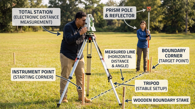
Construction Surveying
Construction surveyors transfer a design from paper to the ground. They help crews know where to place roads, foundations, utilities, and grades. On a construction site, a surveyor’s stake or mark often tells workers exactly where something belongs.
Geodetic and GPS Surveying
Geodetic surveying looks at larger areas and takes the shape of Earth into account. This is the world of control points, satellite positioning, and highly precise coordinates. It supports mapping systems, major engineering projects, and the location tools many people use every day.
Hydrographic Surveying
Some surveyors work on or under water. Hydrographic surveying maps shorelines, river bottoms, harbors, and other underwater areas. It is important for navigation, construction, and environmental studies.
Next Steps
Your first requirement focuses on something every real survey crew needs: field safety. Before you set up instruments and measure angles, learn how to prevent and respond to the injuries and hazards that can happen outdoors.