Req 4 — Finding Elevations from a Benchmark
Maps show position, but surveyors also care about height. Requirement 4 introduces leveling, which is how a crew finds whether points are higher or lower than a benchmark. This matters whenever land will be drained, graded, built on, or connected to roads and utilities.
Start from the benchmark
A benchmark is a point with a known elevation. In this requirement, you are using an assumed elevation of 100 feet. That gives you a starting value so you can calculate the elevation of the other four corners.
The benchmark does not need to represent the true height above sea level for this exercise. It only needs to be a dependable starting point that lets you compare all the other points consistently.
🎬 Video: Calculate Elevation & Grade with a Builders Level (video) — https://youtu.be/UDuYrsxHmrA?si=IV8K7mULkWQKU43P
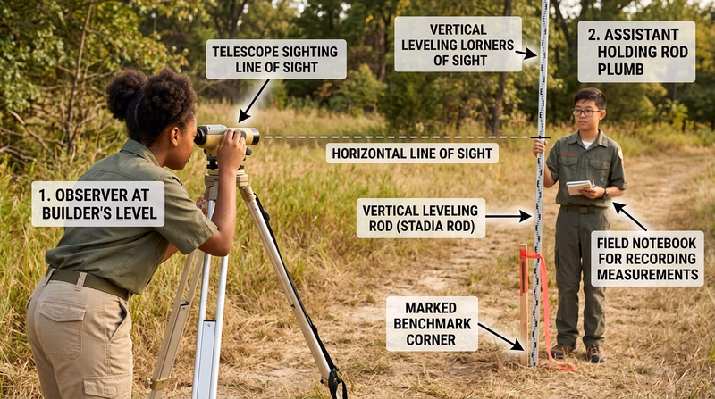
How the level and rod work together
The level creates a horizontal line of sight. The rod gives you a reading at each point. By comparing rod readings, you can determine whether another corner is above or below the benchmark.
A common pattern is:
- take a reading on the benchmark
- establish the height of instrument
- take readings on the other corners
- calculate each point’s elevation from those numbers
Leveling Workflow
Keep each step in order
- Set the level on stable ground: A shaky tripod leads to shaky confidence.
- Level the instrument carefully: Recheck before taking readings.
- Hold the rod upright: A leaning rod changes the reading.
- Record every value immediately: Mark which corner each reading belongs to.
- Double-check math: One copied number can change every later result.
Example idea
If the benchmark is 100.00 feet and your first rod reading there is 4.25 feet, the height of instrument would be 104.25 feet. If another corner reads 5.10 feet, that corner would be 99.15 feet. The exact numbers in your exercise may differ, but the pattern stays the same: benchmark first, then compare every other reading back to it.
Why elevation matters in real surveying
Knowing that one corner is a little higher or lower than another can affect major decisions. Builders care about whether water will run toward or away from a structure. Road crews care about smooth grades. Engineers care about drainage, erosion, and how to move water safely across a site.
Common mistakes to avoid
Survey leveling is straightforward, but it punishes rushed work.
You have now measured the lot in two ways: horizontally with angles and distances, and vertically with elevation. Next, you will move from fieldwork into the record side of surveying by examining a real deed.