Req 6 — Drones and Laser Scanning
Surveying is still built on accuracy, field judgment, and careful records, but the tools keep changing. Requirement 6 asks you to look at two important technologies that can capture data faster and in new ways: drones and laser scanning. Neither tool is magic. Each one works best in certain situations and comes with tradeoffs.
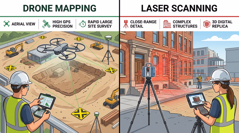
Drones in surveying
A drone can collect images from above and help create maps, models, and site views that would be slow to gather from the ground alone. This is especially useful on large, open sites where a crew needs a broad look at terrain or construction progress.
Strengths of drones
- cover large areas quickly
- reach viewpoints that are hard to get from the ground
- create aerial imagery for maps and planning
- help document changes on a site over time
Weaknesses of drones
- need trained operators and safe flight planning
- may be limited by weather, wind, battery life, or airspace rules
- struggle in dense tree cover or places where the ground is hidden from above
- still need good ground control to support accurate results
Laser scanning
Laser scanning, often called LiDAR scanning in many contexts, captures huge numbers of points to create a detailed 3D model of a place. Instead of measuring one point at a time, the scanner records a dense cloud of points that shows surfaces, shapes, and structures.
Strengths of laser scanning
- captures complex shapes in rich detail
- creates strong 3D records of buildings, sites, and surfaces
- helps measure places where many points are needed
- can reduce the need to revisit a site just to grab one missed measurement
Weaknesses of laser scanning
- equipment and processing can be expensive
- data files can be very large and require specialized software
- scanning hidden or blocked areas may still require multiple setups
- more data does not automatically mean better decisions unless the crew manages it well
🎬 Video: Photogrammetry vs LiDAR - Which Is BETTER? (video) — https://youtu.be/NF2k8e6kvUY?si=QEKCX3GJuHW_wtkX
How to Compare New Survey Tools
Good points to cover with your counselor
- Speed: Which tool gathers information faster for the type of site you have?
- Detail: Do you need a broad overhead map or a dense 3D model?
- Cost: What equipment, training, and software are required?
- Site limits: Will trees, buildings, weather, or regulations affect the work?
- Accuracy needs: What level of precision does the project demand?
Why both still need human judgment
A drone can collect images. A scanner can collect millions of points. But a surveyor still decides where control points belong, what data matters, how to check accuracy, and how to explain the results. Technology can speed up collection, but it does not replace professional judgment.
You have explored two newer ways surveyors capture data. Next, you will focus on one technology almost everyone knows by name: GPS.