Req 7 — Why GPS Matters in Surveying
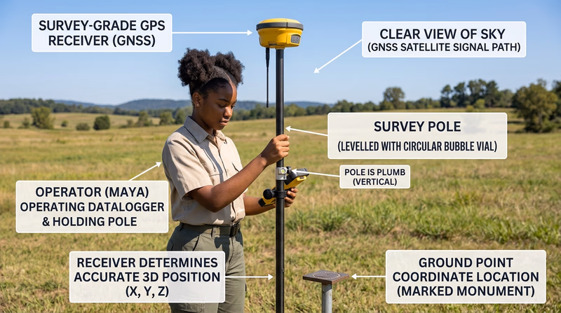
GPS stands for Global Positioning System. It is a satellite-based system that helps a receiver figure out position by comparing signals from multiple satellites. For everyday users, that might mean getting directions on a phone. For surveyors, it means locating points on Earth with far greater speed and reach than older methods alone could provide.
What GPS does
A GPS receiver listens for timing signals sent by satellites. By comparing how long the signals took to arrive, the receiver can estimate where it is. Survey-grade equipment improves that process with stronger hardware, correction methods, and careful procedures so the final position is much more precise than what a phone usually gives you.
🎬 Video: How Does GPS Work? | The Secret Genius of Modern Life | BBC Earth Science (video) — https://youtu.be/KItEcCJfHAs?si=ta74Ncw563CCpist
Why GPS is important to surveyors
GPS changed surveying because it reduced the need to measure every position by chaining lines from one visible point to the next. Surveyors can now establish control, check positions, and connect projects across long distances much more efficiently.
Ways GPS helps the profession
- speeds up positioning over large areas
- supports mapping, construction layout, and control work
- helps crews work where long lines of sight are difficult to maintain
- connects local projects to broader coordinate systems
Why GPS did not replace everything else
GPS is powerful, but it is not perfect everywhere. Tree cover, buildings, terrain, and signal issues can reduce accuracy or slow down work. That is why surveyors still use total stations, levels, and other tools alongside GPS.
GPS Strengths and Limits
Balanced points to bring into your discussion
- Strength: Works well for wide-area positioning and connecting points over distance.
- Strength: Can save time compared with older point-to-point methods alone.
- Limit: Signal blockage can reduce reliability near buildings, cliffs, or heavy trees.
- Limit: Good results still depend on proper equipment, setup, and checks.
How GPS is changing surveying
GPS has made surveying faster, more connected, and more digital. Crews can move data into mapping software quickly, coordinate projects across regions, and tie their work into broader geographic systems. It also supports newer technologies you saw in the previous requirement, because drones, digital mapping, and many modern workflows rely on accurate positioning.
You now understand one of the biggest tools shaping modern surveying. Next, you will turn that knowledge toward people by exploring careers that depend on these skills.