Req 4 — Pressure Systems and Fronts
A weather map can look crowded with lines, arrows, and symbols, but it is really showing one big story: where air is sinking, where air is rising, and where different air masses are meeting. Once you understand pressure systems and fronts, a forecast starts to make much more sense.
High pressure vs. low pressure
Air pressure is the weight of the air above you pushing downward. Meteorologists track areas where pressure is relatively higher or lower than nearby places.
High-pressure systems
High pressure is usually linked with sinking air. Sinking air tends to warm and dry out, which makes cloud formation less likely. That is why high pressure is often connected with fair or calmer weather.
Fair does not always mean perfect. High pressure can also bring hot, still summer days, cold winter nights, fog trapped near the ground, or stale air that does not mix well. But in everyday weather talk, high pressure is usually the system connected with more settled weather.
Low-pressure systems
Low pressure is usually linked with rising air. Rising air cools as it expands, and cooler air is more likely to form clouds and precipitation. That is why low pressure is often related to poorer weather, including rain, snow, stronger winds, and stormier conditions.
The Weather merit badge pamphlet also notes that low-pressure regions often dominate the boundaries between air masses, where active weather develops.
🎬 Video: Weather 101: High Pressure vs. Low Pressure (video) — https://youtu.be/8mHEry8tSPM?si=_Rx2aPuB2UpvW9o1
What is a front?
A front is the boundary where two different air masses meet. Those air masses may differ in temperature, moisture, or both. Because they behave differently, the boundary between them is often where important weather happens.
The Weather merit badge pamphlet describes fronts as regions of transition. That is a good phrase to remember. Fronts are change zones.
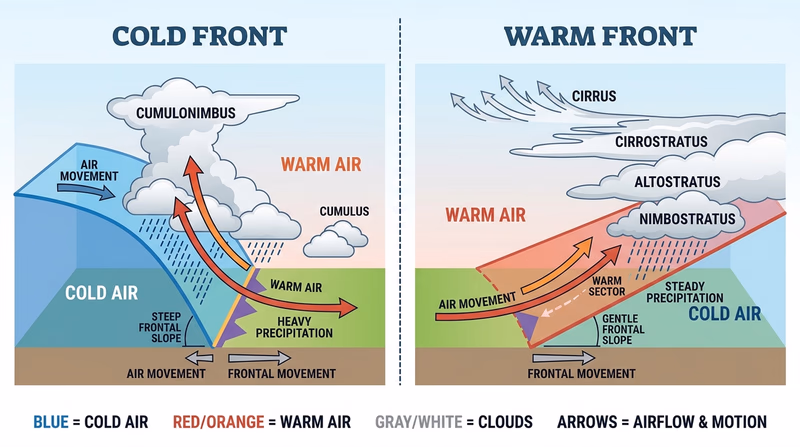
Cold fronts
A cold front forms when colder, denser air replaces warmer air. Because the cold air stays near the ground and wedges underneath the warm air, the warm air is forced upward rather quickly.
That quick lift often creates:
- a steeper frontal slope
- a narrower band of active weather
- towering clouds such as cumulonimbus
- showers or thunderstorms near the front
Cold fronts can bring dramatic changes in a short time. Temperature drops, wind shifts, and stormy weather may arrive quickly.
Warm fronts
A warm front forms when warmer air replaces colder air. Warm air tends to glide up and over the cooler air instead of shoving underneath it. That produces a gentler slope.
That gentler lift often creates:
- layered clouds spreading out ahead of the front
- precipitation that may begin before the front passes
- a longer, more gradual change in weather
The Weather merit badge pamphlet explains that clouds and rain can arrive a day or more before a warm front actually passes.
🎬 Video: What Are Weather Fronts? Warm Front, Cold Front? (video) — https://youtu.be/5Cnx5Bzctas?si=bJcnCUw3ysbD99rD
What to include in your drawings
For your counselor, your cross sections should show more than two arrows and a label. Make sure your drawing includes all of these elements:
| Feature | Cold front | Warm front |
|---|---|---|
| Which air mass is advancing | Cold air | Warm air |
| Slope of the front | Steep | Gentle |
| Typical clouds | Cumulonimbus, stratocumulus | Stratus, nimbostratus |
| Where precipitation tends to form | Near or just ahead of the front | Ahead of the front over a broader area |
| How weather changes | Faster and more dramatic | Slower and more gradual |
Sky clues you can notice outdoors
You do not need a giant weather center to notice fronts. The pamphlet describes how a frontal system may be announced by a procession of cloud types. High wispy cirrus may appear first, then thicker layered clouds, and finally dark rain clouds. A swelling cumulus cloud, on the other hand, can warn you that a cold front or unstable air may be building toward thunderstorms.
This connects closely to Req 6, where you will identify cloud types and relate them to weather.
Pressure systems and fronts explain the big picture. Next you will zoom in on the processes that create wind, rain, lightning, and hail inside those weather systems.