Req 6 — Cloud Clues
Clouds are one of the easiest weather tools to use because you can see them without special equipment. A Scout who learns to recognize a few common cloud families can often guess whether the weather is staying calm, changing gradually, or building toward rain or storms.
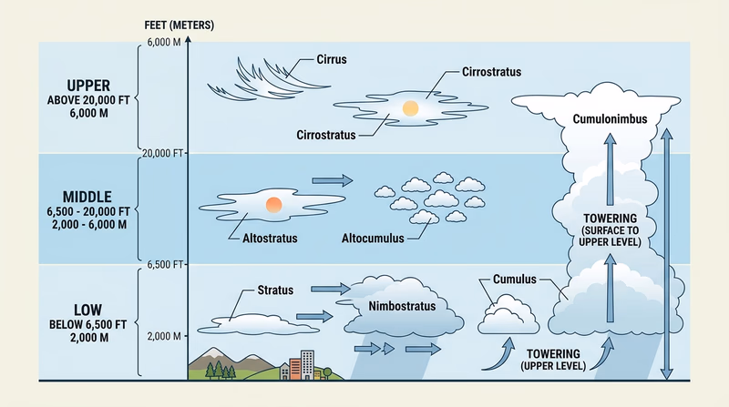
Upper-level clouds
High clouds form in the colder upper part of the atmosphere and are often thin or wispy because they are made largely of ice crystals.
Cirrus
Cirrus clouds look feathery or streaky. They often appear in fair weather, but they can also be the first sign that a change is coming.
Cirrostratus
Cirrostratus clouds form a thin veil across the sky. They can make the sun or moon look hazy and may create halos. They often show that moisture is increasing high in the atmosphere and that a warm front may be approaching.
Cirrocumulus
Cirrocumulus clouds appear as small ripples or patches, sometimes called a “mackerel sky.” They may still mean fair weather, but they can also hint that the atmosphere is changing.
Middle-level clouds
Middle clouds are thicker and often appear gray or layered.
Altostratus
Altostratus clouds spread across the sky as a gray blanket. The sun may still show through dimly. The Weather merit badge pamphlet notes that altostratus often indicates an approaching warm front and a change toward rain or snow.
Altocumulus
Altocumulus clouds look patchy or clumped. They can be part of fair weather, but if they build and thicken in warm, humid conditions, they may signal growing instability.
Low-level clouds
Low clouds are closest to the ground and often have the clearest connection to immediate local weather.
Stratus
Stratus clouds form a low gray layer, almost like fog lifted off the ground. They often bring gloomy skies, mist, or light drizzle.
Stratocumulus
Stratocumulus clouds appear lumpy or rolled but still stay in a broad layer. They may bring little precipitation, though they can help show that cooler air is moving in.
Nimbostratus
Nimbostratus clouds are dark, thick, and widespread. They are classic rain-or-snow clouds that often bring steady precipitation.
Towering storm clouds
Cumulus
Small puffy cumulus clouds are common in fair weather. On a warm day, they often mean the atmosphere is bubbling upward but not yet severe.
Cumulonimbus
Cumulonimbus clouds are the giants of thunderstorm weather. They grow tall because strong rising air is carrying moisture upward fast. These clouds are linked to lightning, heavy rain, hail, strong winds, and sometimes tornadoes.
🎬 Video: What Are the Different Types of Clouds? (video) — https://youtu.be/JIkEMBiT6hQ?si=3bZrjTTiTTFmspzQ
Matching clouds to weather
| Cloud type | Level | Common weather clue |
|---|---|---|
| Cirrus | Upper | Fair weather now, but change may be coming |
| Cirrostratus | Upper | Moisture increasing aloft; front may be on the way |
| Altostratus | Middle | Thickening sky; rain or snow may follow |
| Stratus | Low | Gray, damp, drizzly weather |
| Nimbostratus | Low | Steady rain or snow |
| Cumulus | Low to growing vertical | Fair weather if small and scattered |
| Cumulonimbus | Towering vertical | Thunderstorms and severe weather risk |
Watching a weather change unfold
The pamphlet describes a common sequence before a frontal system arrives: high wispy clouds first, then a thicker veil, then darker layered clouds, and finally precipitation. That sequence is useful because it shows that clouds are not random decorations. They are clues to what the atmosphere is doing.
This connects directly to Req 4. Fronts help explain why cloud types change in a predictable order.
Next you will follow the moisture itself. The water cycle explains how evaporation, condensation, and precipitation connect the sky, the ground, and the oceans into one moving system.